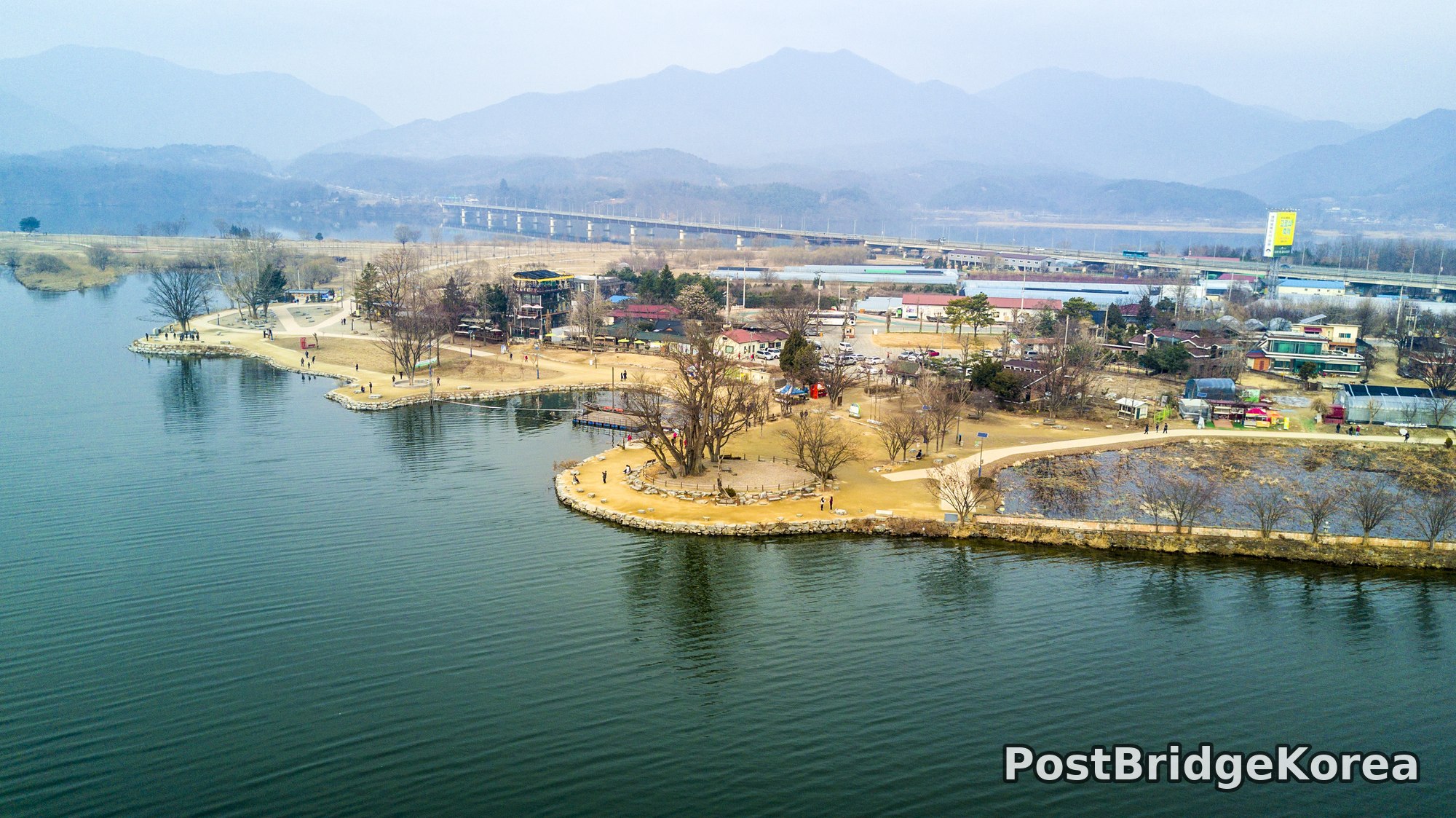

The Visual and Geological Value of Aerial Drone Photography in This Terrain and Season

The first thing on screen was water. Everywhere. From the air, Dumulmeori stops looking like a park and starts looking like what it actually is: a narrow finger of land where two rivers press against it from almost every direction, leaving only a thin land bridge connecting it to the broader plain behind. That geometry is completely invisible from ground level. You need altitude to understand it.
I shot this on March 12, 2017, technically still winter by the trees. The bare branches had not yet leafed out, and the reed beds visible in the second frame were a uniform dried-gold against the dark river. That seasonal nakedness is a gift to drone photographers. With no canopy blocking the view, the full masterplan of the site — its paved walking loops, its stone-reinforced banks, the internal pond carved into the wetland section — reads cleanly from above. In summer, dense foliage would swallow half of that structure.
The light that day sat low and slightly hazy, which I’ve come to associate with early Korean spring before the pollen and yellow dust season fully kicks in. The mountains in the far background were soft, almost silhouetted in blue-grey, and that atmospheric depth gave the wide-angle frames a natural three-layer quality without any post-processing. The water surface was picking up just enough wind to show fine ripple texture rather than mirror-flat reflection, which added visual weight to the foreground and helped the small uninhabited islet in the third shot sit with more presence than it would on a perfectly still day. The reflection of the bare trees in that frame is one of those things phone photos simply cannot replicate. You need to be directly above, perfectly centred, to get the vertical symmetry of branch and water image lined up at the same time.
Spatial Composition and Landmark Analysis: Foreground, Midground, Background

Breaking down what is actually visible across the four frames:
Foreground (water surface and immediate shoreline):
– Dark river water dominates the lower half of frames 1 and 4, with ripple texture confirming a light surface wind from the northwest
– Stone-reinforced retaining walls line the peninsula’s outer edge, clearly engineered rather than natural bankside
– In frame 2, dried reed beds and a shallow internal pond sit at the tip of the wetland section; the pond’s dark water contrasts sharply with the pale dead grass surrounding it
– Frame 3 centres entirely on a small, unnamed islet: bare deciduous trees, low scrubby ground cover, and a partial reflection in the olive-green river
Midground (the peninsula itself and its built infrastructure):
– A multi-storey open-frame timber or steel structure visible in frames 1 and 4, likely a viewing tower or cafe building, sits near the central cluster of commercial units
– Paved pedestrian paths in frame 2 follow long, sinuous curves across the open grassland — clearly a designed park layout rather than organic footpaths
– A wooden boardwalk extends from one of the paths out over the internal wetland pond, visible as a short straight pier in frame 2
– Scattered low-rise buildings: a structure with a red roof, another with a blue roof (solar panels visible in frame 4), and several small commercial kiosks along the waterfront promenade
– Visitors on foot are visible at multiple points along the stone-edged promenade in frames 1 and 4, confirming the site was open and moderately busy for a mid-week spring day
– A small rowing boat moored at the lower-left bank edge is visible in frame 4
Background (beyond the peninsula):
– A long concrete multi-span road bridge crosses the river valley in frame 1, running roughly east-west behind the site
– Beyond the bridge, low industrial and agricultural structures are visible including polytunnel greenhouses to the upper-left in frame 4
– A range of hills and mountains fills the horizon in frames 1 and 3; they recede in multiple parallel ridges with progressive atmospheric haze, adding significant depth to any wide composition
– A large yellow commercial billboard is visible at the right edge of frame 1, marking the roadside approach
Recommended Drone Camera Settings and Composition Tips for This Shooting Condition

For this kind of overcast-to-hazy late-winter light over open water, the main exposure challenge is dynamic range. The sky is bright but featureless, the water is dark, and the sand-coloured ground sits somewhere in between. To hold all three zones without clipping the sky or crushing the river, an exposure compensation of around -0.3 to -0.7 EV is worth trying as a starting point, then adjusting from there based on your histogram. Shooting in a flat or D-Log profile if your camera supports it will give you more flexibility in post to recover the pale sky and the shadow detail in the reed beds at the same time.
Aperture in the f/5.6 to f/8 range is generally recommended for this type of aerial overview work. That window typically maximises pan-focus across the full depth of the scene — from the stone retaining wall directly below to the mountain ridges on the horizon — without introducing diffraction softness. For ISO, keeping it at the base value (commonly 100 on most drone cameras) is advisable when light levels allow, to preserve clean shadow detail in the dark river surface. A circular polarising filter (CPL filter) is worth considering here: at the angle these frames were taken, it could meaningfully reduce the grey surface glare on the river and bring through more of the water’s actual colour and depth, which from the third frame looks like a rich dark olive-green.
On composition, the peninsula shape itself does most of the structural work. For wide establishing shots like frame 1, a three-layer framing approach works naturally: dark water in the foreground third, the peninsula’s built interior in the middle third, and the hazy mountain ridges filling the upper third. People usually describe Dumulmeori as a riverside picnic spot, but from above it reads more like a carefully engineered landform dropped into a river system — the designed paths and reinforced banks make that clear in a way no ground-level sign ever could. The sinuous paths in frame 2 are a strong invitation for one-point perspective: position the camera so one of those curves leads directly away from the lens into the centre of the frame, and the eye follows it back through the wetland to the river beyond. For the islet shot in frame 3, centring the subject against the reflection creates a near-perfect vertical axis of symmetry — the kind of composition that only works when the wind drops and the water surface briefly settles. Patience is the only setting you cannot dial in.
Outdoor Drone Flight Safety and Regulatory Checklist for This Terrain and Season
Before flying anywhere near a river confluence like this, check the airspace status through an official airspace or no-fly-zone lookup tool before you even pack the car. River zones and public parks in South Korea can carry flight restrictions that are not obvious from the ground, and those restrictions can vary by altitude, by time of day, or by the specific parcel of land. If the site is managed, it is worth contacting whoever runs it to ask whether drone operations require any kind of prior permission from the site manager. Do not assume that because a place looks open and uncrowded it is unrestricted.
In March, cold-weather battery management matters more than many pilots expect. At this time of year in central Korea, morning temperatures can still drop below the threshold where lithium battery chemistry starts to deliver meaningfully less capacity than the stated rating. Recommended practice is to keep batteries warm in an insulated case until just before takeoff, check the charge level again after a brief hover, and set a conservative low-battery RTH (Return-to-Home) trigger higher than you might in summer. The water on all sides here means there is no safe forced-landing option if you push a battery too far.
The terrain itself presents two specific caution points. First, the internal pond and the river edges in frame 2 mean the drone’s downward vision sensors may struggle over open water surfaces, particularly in lower light or when the water is rippled, since those sensors rely on texture contrast to hold altitude. Manual altitude control or a barometer-only hover mode is a safer choice over water. Second, with visitors visible on foot throughout the promenade area, maintaining a safe horizontal distance from people at all times is essential — not just as a legal matter but as a basic duty of care. Set your RTH altitude to clear the multi-storey viewing structure visible in the midground before any automated flight path is engaged.
Leave a Reply