
The Visual and Geological Value of Aerial Drone Photography in This Terrain and Season

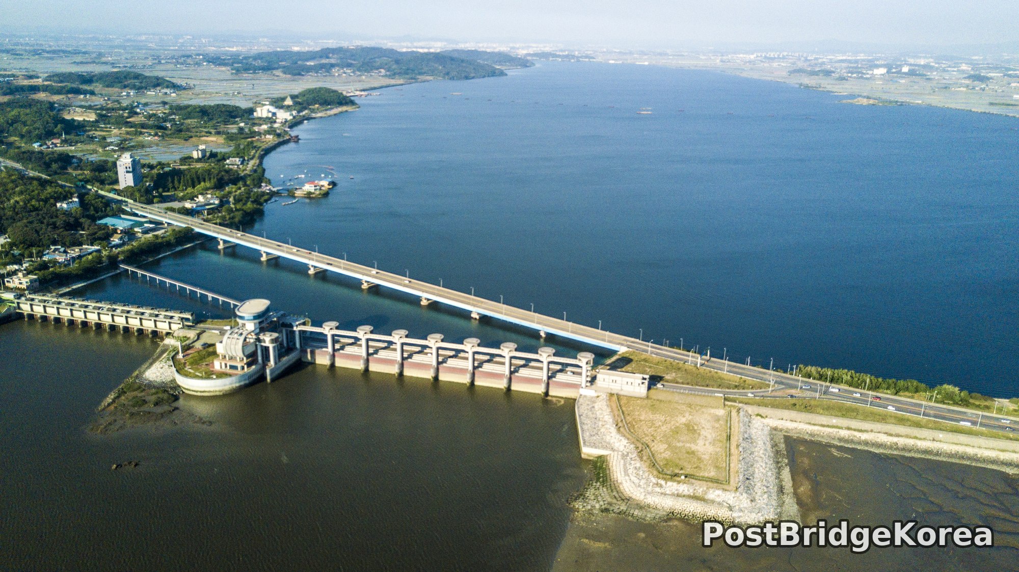
The first thing on screen when I pulled up the footage was water. Everywhere. And the shocking thing is how differently the water reads on each side of that tidal gate. Standing at ground level, you would never grasp it. From the air, the contrast is immediate: the upstream reservoir holds a deep, still blue, while the downstream tidal flat sits darker, murkier, the colour of cold tea. That single structural fact, two water bodies held at different salinity and depth by one concrete barrage, is completely invisible from the roadside. Aerial photography earns its keep here.
The shoot date was May 21, 2017, deep into spring. The light sits low enough in the morning to throw long, diagonal shadows across the embankment and the shoreline trees, giving the concrete structures a clear three-dimensional relief that midday flat light would erase. Side lighting at this angle is exactly what you want over engineered infrastructure: every gate pillar casts a shadow, the riprap revetment on the downstream apron reads in textured detail, and the grid of aquaculture ponds inland catches the low sun at a slight glitter. The water surface on the reservoir side reflects the sky with enough saturation to hold colour across the whole frame without blowing the highlights.
What the aerial vantage also reveals, and this is something phone photos at the lakeside pavilion genuinely cannot show, is the masterplan logic of this place. The tidal barrage, the dual carriageway running along its crest, the crescent-shaped leisure shoreline with its rental boats and floating pavilion, and the flat agricultural hinterland behind it all read as one coherent planned system only from above. People usually say this kind of industrial infrastructure is ugly. From 150 metres up, the rhythm of the gate bays and the geometry of the riprap apron look almost deliberate.
Spatial Composition and Landmark Analysis: Foreground, Midground, Background

Breaking the four photos down by depth gives you a clear map of the site’s key features. Because the shots cover different altitudes and orientations, the same structures appear at different depths depending on the frame.
Foreground elements (closest to camera, lowest in frame or sharpest in detail):
– The tidal barrage itself: a long concrete structure carrying a dual-lane road across its crest, with evenly spaced gate bays below, each topped by a circular mechanical housing for the sluice gate winches
– The downstream riprap apron: a broad rectangular stone-armoured platform extending from the southern end of the barrage into the tidal flat, clearly showing the hydraulic engineering margins built to absorb gate discharge
– The floating boom and marker buoys forming a curved enclosure on the reservoir surface, visible in both the close top-down shot and the wider oblique frames, indicating a designated aquaculture or swim-zone boundary
– A small motorboat mid-turn inside the reservoir, its wake forming a tight spiral that makes the water surface readable as genuinely calm that morning
Midground elements (middle distance, giving the scene its spatial scale):
– The octagonal lakeside pavilion building with the terracotta-tiled roof, sitting on a small rocky islet connected to the shore by a pedestrian bridge; this is the recreational centrepiece of the shore zone
– A blue-roofed commercial building on a floating pontoon adjacent to the pavilion, with paddle boats and small rental craft moored alongside
– The curved promenade embankment running north from the pavilion, with scattered moored boats, and what appears to be a car park set back behind a dense treeline of mature deciduous trees
– Inland from the shoreline, the flat grid of aquaculture or salt production ponds, their reflective surfaces tiling the agricultural hinterland into a geometric pattern that reads strongly in the wider shots
Background elements (furthest from camera, horizon zone):
– A low wooded hill or island mass on the far side of the reservoir, its ridgeline running roughly east-west and forming a natural horizon stop
– Beyond the treeline, the distant spread of a town or city, hazy in the morning air but legible as a dense built-up area, likely the port urban fringe
– The reservoir itself extending away into the mid-distance, its surface unbroken and deep blue, contrasting with the disturbed tidal water downstream
Recommended Drone Camera Settings and Composition Techniques for This Shooting Condition

For a scene like this, the main exposure challenge is the contrast between the dark tidal water downstream and the bright reflective reservoir surface upstream, with concrete structures in between. The dynamic range demand is real. I would recommend exposing to protect the reservoir highlights first, then pulling shadow detail in post rather than the reverse: blown-out water reflections are unrecoverable, while dark riprap stone can be lifted. An exposure compensation of around -0.3 to -0.7 EV relative to the drone’s metered reading is a reasonable starting point in this kind of mixed-surface, side-lit condition. For aperture, f/5.6 to f/8 is the typical sweet spot for drone lenses at this focal length to achieve pan-focus across the full depth of a scene this large, keeping both the barrage detail in the foreground and the distant treeline acceptably sharp. ISO 100 is recommended to keep noise low; the spring morning light in these frames is clearly sufficient to hold that base sensitivity without underexposure.
A circular polarising filter (CPL) would be worth fitting here. The reservoir surface reflection is strong, and a CPL at the right rotation angle can deepen the blue significantly while reducing glare on the concrete gate housings. The downstream tidal area, being darker and more turbid, benefits less, but the upstream half of the frame will look noticeably cleaner. ND filters are less critical at this time of day if you are shooting stills, but for video work an ND8 or ND16 would help maintain a cinematic shutter speed.
On composition: the barrage structure naturally offers a one-point perspective opportunity when shot from directly above and slightly oblique. The gate pillars recede in a single converging line from the near end to the far bank, drawing the eye across the frame with almost no effort. For the wider oblique shots showing both the barrage and the leisure shoreline, a three-layer framing approach works well: position the embankment road as the foreground diagonal, the reservoir surface as the midground fill, and the distant hill as the background horizon. The curved promenade is a strong compositional asset too; aligning it along the lower third of the frame gives the photo a natural sweep without the composition feeling forced. For the top-down boat-wake shots, the spiral wake pattern is essentially self-composing. Centre it slightly off-middle and let the boom line provide a secondary curve to prevent the frame from feeling static.
Outdoor Drone Flight Safety and Regulatory Checklist for This Terrain and Season
A site like this combines several terrain types that each carry specific risks, so the pre-flight checklist is worth taking seriously. The barrage structure spans moving water on the downstream side and a large open reservoir on the upstream side. Water surfaces are notoriously unreliable for the downward-facing vision sensors most consumer drones use for position hold: the sensor struggles to find stable reference points on a reflective or featureless water surface, which can cause unexpected altitude drift. Set a manual GNSS-only position hold mode if your aircraft supports it, and keep your return-to-home (RTH) altitude well above any structures on the barrage crest before launch.
This is a port-adjacent location with an active road running across the barrage crest and what appears to be ongoing aquaculture activity on the reservoir. Before flying, check the airspace status of the area through an official airspace or no-fly-zone lookup, and confirm with the site manager or relevant authority that recreational drone use is permitted in this zone. Port and industrial waterway areas frequently carry additional airspace restrictions that are not always obvious from a general map view. Do not assume open water means open airspace.
For a May morning shoot, battery performance should be close to nominal, but Korean spring mornings can still be cool enough to reduce capacity slightly if the cells have not been pre-warmed. Keep spare batteries in an insulated case out of direct wind until launch, and watch the first battery’s discharge curve carefully as a calibration point for the rest of the session. Wind over open water tends to be steadier than over urban areas but can gust unexpectedly near structures like barrage gates where airflow is channelled. Launch from a stable, dry surface away from the water’s edge, and always identify a clear emergency landing zone before you arm the motors.
Leave a Reply