
The Visual and Geological Value of Aerial Drone Photography at This Terrain and Season

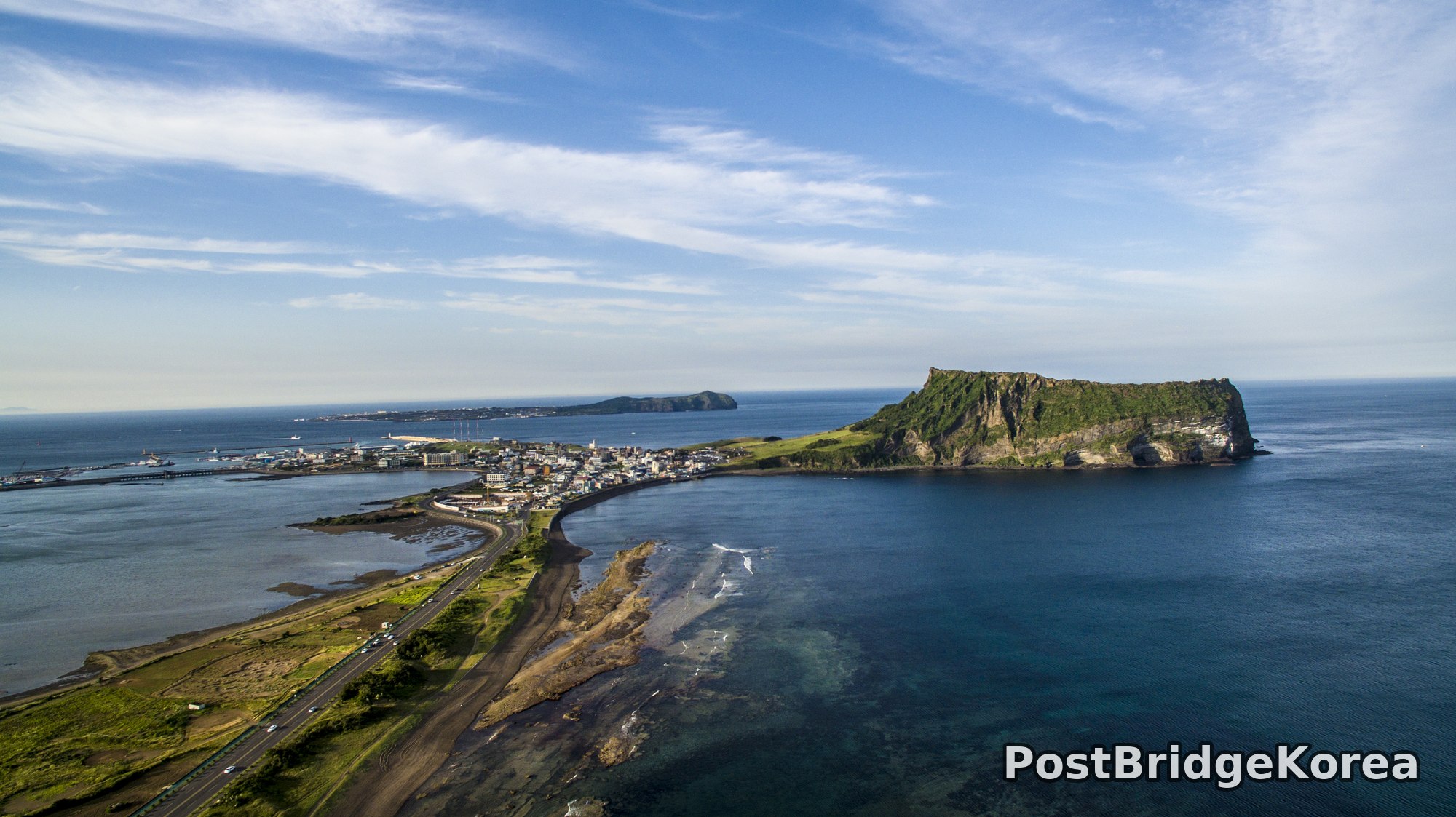
The first thing on screen when I lifted off was scale. From the ground, Seongsan Ilchulbong reads as a dramatic cliff you stand beneath and stare up at. From altitude, it becomes something else entirely: a broad, flat-topped volcanic tuff cone sitting at the eastern tip of Jeju Island, three sides sheer rock face and one side trailing off into a narrow land bridge connecting it to the rest of the coast. That geometry is simply invisible at ground level. The spring shoot date, late May, gave the crater rim its deepest possible green, the grass fully in and the scrub trees dense enough to read from altitude as a solid mat of colour rather than individual plants.
The light that day was working well. Soft, slightly hazy spring sky with a mix of high cloud and clear blue. No hard shadows cutting across the cliff face, which matters because Ilchulbong’s south and east walls are columnar basalt in vertical relief; harsh midday sun would blow out the highlights on those pale cliff faces and block up the shadows in the same frame. The diffused spring light held detail in both. That’s the kind of condition you can’t plan for exactly, but you can chase seasonally: late May on Jeju typically brings this quality of soft brightness before summer haze thickens. From the air, the black volcanic sand beach stretching south-west from the base of the formation, the reef shallows showing as pale turquoise over the dark ocean floor, and the coastal road tracing the shoreline all become compositional elements the ground photographer never gets to arrange simultaneously.
The tea field shot required a completely different mindset. Pointing straight down over the O’Sulloc plantation rows near Jeju’s western interior, the camera becomes almost abstract. The rows read as pure repeated geometry, the two slightly different shades of green indicating slightly different row heights or leaf density across adjacent plots. People usually describe tea fields from the side, but from directly above they stop being agriculture and start being graphic design. Spring is the right season for this: the first flush leaves are freshly clipped and dense, so the rows hold their sharp-edged, manicured profile cleanly.
Spatial Composition and Landmark Analysis: Foreground, Midground, Background

These four photos cover the same shoot but address very different focal distances and directions. Breaking each down:
**Coastal aerial, Seongsan Ilchulbong summit and town:**
– Foreground: black volcanic sand beach and exposed tidal rock shelf, coastal highway running along the narrow isthmus, shallow reef water showing pale turquoise gradients
– Midground: the low-rise Seongsan township clustered around the small harbour on the western side of the land bridge, the harbour pier and breakwater structures, Ilchulbong’s southern cliff face rising steeply with its columnar basalt walls and green-capped summit plateau
– Background: open Korea Strait to the south and east, a second low island or islet visible mid-horizon to the north-west (consistent with the position of Udo Island from this vantage point), shipping on the horizon
**Jeongbang Waterfall aerial:**
– Foreground: tumbled basalt boulder field at the base of the cliff, the dark plunge pool, a small rocky beach with a few visitors visible at scale
– Midground: the main waterfall drop, the full height of the columnar basalt cliff face on both left and right sides, pine forest crowning the cliff edge
– Background: low-rise resort and commercial buildings visible above the treeline, hazy sky with no strong cloud definition
**Coastal resort and lagoon aerial:**
– Foreground: a large curved resort complex, its distinctive rounded wing buildings arranged around a central courtyard, access roads and manicured grounds, a small glass-roofed greenhouse structure to the lower left
– Midground: dark lava-rock coastline immediately below the resort, a sheltered oval lagoon or coastal pond behind the resort to the east showing clear turquoise water, a small marina or harbour breakwater with a lighthouse visible mid-frame
– Background: low agricultural fields and scattered residential development stretching north, Jeju City’s taller buildings faintly visible on the distant northern horizon, Hallasan’s silhouette just legible in the furthest distance
**Tea field nadir aerial:**
– Foreground/entire frame: closely planted tea bush rows trimmed to flat-topped ridges, two slightly offset blocks of rows meeting at a horizontal seam running across the mid-frame, the colour difference between the two blocks suggesting either different clipping dates or slightly different cultivar
– No midground or background — this is a pure nadir (straight-down) shot with no horizon
Recommended Drone Camera Settings and Composition Tips for This Shooting Condition

For the coastal cliff and summit shots, the primary exposure challenge is the simultaneous presence of bright open ocean, pale basalt cliff faces, and deep shadow on the landward side of the formation. A starting exposure compensation of around -0.3 to -0.7 EV is worth trying when the sky occupies more than a third of the frame; protecting the highlights in the cloud detail and the pale cliff face prevents the kind of blown-out white patches that flatten the geology. An aperture around f/5.6 to f/7.1 is generally recommended for this type of wide aerial scene where pan-focus is the goal: you want the foreground reef, the mid-distance town, and the background horizon all rendering with detail simultaneously, and stopping down beyond f/8 on smaller drone sensors risks diffraction softening. Keep ISO as low as the sensor allows in these spring daylight conditions, with ISO 100 as the target.
A circular polarising filter (CPL) is worth considering specifically for the reef and lagoon shots in this set. The shallow turquoise water over Jeju’s basalt reef shows significant surface glare in midday spring light, and a CPL can cut that specular reflection enough to let the seafloor geology read through. It won’t help in the nadir tea-field shot, since there’s no reflective surface, but for the coastal compositions it makes a meaningful difference to the water’s transparency in the final image.
For the one-point perspective geometry of the tea field, a true nadir (camera pitched to exactly 90 degrees downward) is recommended to keep the rows parallel rather than converging. Any slight forward tilt introduces a vanishing point that pulls one edge of the rows smaller, breaking the graphic flatness that makes this composition work. Position the drone so the seam between the two blocks of rows sits close to the horizontal centre of the frame rather than at a third. Here, symmetry outperforms the rule of thirds because the subject is already so abstract. For the waterfall, the approach that works best in diffuse spring light is a slight low-angle attitude rather than a steep downward look: keeping the cliff face visible across most of the frame makes the waterfall’s height legible, whereas a steep nadir would show mostly boulders and pool. A three-layer framing, boulder field, cliff and waterfall, sky and treeline, fits naturally into a standard 16:9 crop from this angle.
In all four compositions here, diagonal lines are the strongest structural element available: the coastal road curving south-west from the isthmus, the cliff edge of Ilchulbong angling toward the horizon, the resort access road cutting through the frame. Aligning one of those diagonals to run from a lower corner toward the subject in the opposing third is the composition decision that gives these shots energy without requiring any dramatic camera movement.
Outdoor Drone Flight Safety and Regulatory Checklist for This Terrain and Season
Seongsan Ilchulbong is a UNESCO World Heritage Site and sits within a designated protected zone. Before flying anywhere in this area, check an official airspace and no-fly-zone lookup to confirm the specific flight status of your intended location, and contact the site management office directly for permission. Do not assume that because a spot looks open it is uncontrolled airspace. This applies to the coastal areas, the waterfall site, and the resort coastline in this set. Requirements can and do change, so check close to your actual shoot date rather than months in advance.
Spring conditions on Jeju’s east coast bring their own technical considerations. The Korea Strait generates consistent sea wind, often stronger at altitude than at ground level, and the cliff edges around Ilchulbong create turbulent updraughts when surface wind hits the vertical face. Set your RTH (return-to-home) altitude well above the summit plateau height before launch, not just above your own standing height, to ensure the drone clears the formation on an automatic return. Vision sensors on most consumer drones have difficulty reading dark lava rock and water surfaces accurately; flying over the black basalt reef or the plunge pool at the base of the waterfall requires extra manual caution and is not a situation to rely on automated obstacle avoidance alone.
Battery performance in late May on Jeju is generally reasonable, but coastal salt air accelerates connector corrosion over time. After any flight in maritime conditions, wipe down the battery contacts and inspect them before the next session. Keep a spare set of fully charged batteries in a shaded location rather than leaving them in direct sun inside a bag or car, since elevated ambient temperature can cause pre-flight self-discharge and affect the capacity readings you see at launch. Plan your flight windows around the wind forecast rather than the light: on a coast this exposed, a wind shift from 4 m/s to 8 m/s can happen quickly, and flying a small drone in gusting conditions near cliff edges significantly reduces your safety margin. Check the marine wind forecast, not just the inland surface forecast, for this site.
Leave a Reply