
The Visual and Geological Value of Aerial Drone Photography in This Terrain and Season

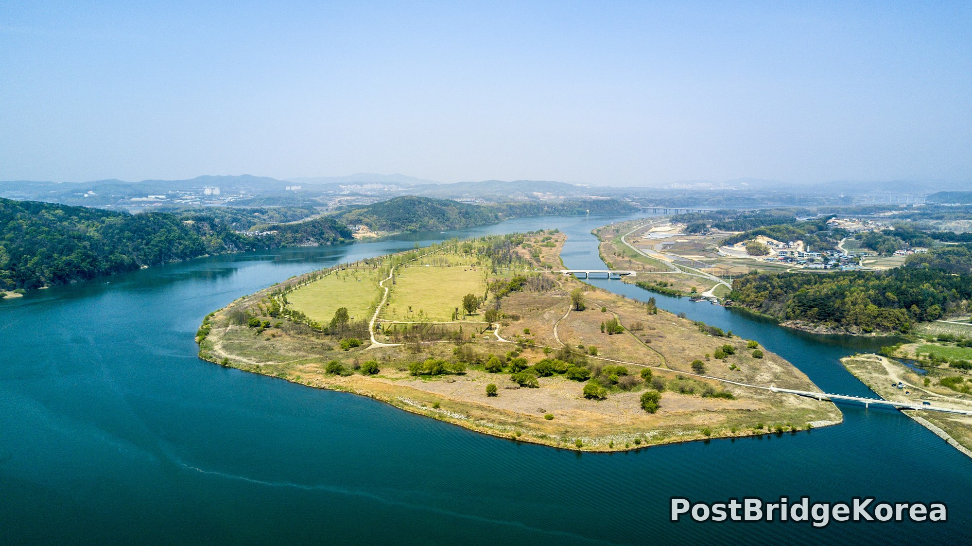
The first thing on screen was water on three sides. Gangcheon Island sits at the confluence of the Namhan River’s broad main channel and a narrower inner channel, and from ground level that geometry is completely invisible. You have to go up to understand it. The late-April shoot date placed the site right at the hinge between dormant brown and new green, which from altitude reads as a kind of two-tone patchwork: the managed grassland at the island’s northern end has fully greened, while the lower, wilder southern tip is still carrying the rust-coloured reed beds of winter. That seasonal split is the main photographic argument for flying this location in early spring rather than waiting for full summer cover, because by May the uniform green would erase the contrast that makes the island’s internal topography legible.
The spring haze softens the distant ridgelines on all sides, compressing depth and pulling the mid-toned water surface forward in the frame. Light quality in the photos suggests midday-adjacent sun from a high angle, with relatively short shadows under the trees and a cool, flat sky. That is not the golden-hour drama most drone photographers aim for, but it has its own advantage here: the water reads as a single, saturated blue-green plane with no harsh glare hotspots, which keeps the eye on the island’s shape rather than fighting reflections. Phone photos taken from the access bridge at the island’s southeastern edge would give you the bridge. From altitude you get the whole story: an elongated leaf-shaped landmass, narrowing to a blunt point in the south, with two concrete span bridges marking the only fixed connections to the river banks, and walking paths threading through the interior like capillaries.
Spatial Composition and Landmark Analysis (Foreground / Midground / Background)

Looking across all three frames, the site breaks down clearly into three depth layers.
Foreground:
– The two concrete span bridges, one at the southeastern tip and a second visible further upstream connecting the island’s midpoint to the eastern embankment road, anchor the lower portions of frames 1 and 3 and give the eye a hard geometric edge to push off from
– The access embankment road running along the eastern riverbank, with what appears to be a small red-roofed boat shed and moored vessel visible in frame 2 near the southern bank
– Bare-branched and newly budding trees along the island’s lower southern margins, their open canopy casting minimal shadow and revealing the dirt footpath network beneath them
– A small cluster of visitors and tents visible on the green northern meadow in frame 3, confirming the site was open and in public use on the shoot date
Midground:
– The island itself as the dominant subject: its northern half featuring a broad, flat, managed lawn with rows of young trees (likely poplars or similar columnar species) planted in a formal allée running roughly north-south, consistent with a riverside park masterplan
– The inner channel (narrow secondary waterway) separating the island’s eastern edge from the embankment road, particularly clear in frame 2 where the channel bends and narrows
– The dirt and gravel walking paths visible from above, forming loose curves through the drier southern section of the island
– Scrub vegetation and reed-edged shoreline on the island’s southern tip, ecologically distinct from the manicured northern lawn
Background:
– Rounded, forested hillsides rising on both the left (western) and right (eastern) banks, their mid-spring green still carrying some bare crown density from the late-waking broadleaf canopy
– A second concrete bridge spanning the river in the far distance, visible in frames 1 and 3, suggesting a road crossing several hundred metres upstream
– Scattered low-rise urban development and what appears to be an industrial or logistics complex on the far left ridge in frame 1, hazy but structurally visible
– Agricultural field plots and solar panel arrays visible along the left bank in frame 2, reinforcing the rural-peri-urban character of the broader valley
– A pale blue-grey sky carrying spring haze, with no cloud structure to speak of, flattening the horizon and giving the whole scene a clean, airy perimeter
Recommended Drone Camera Settings and Composition Tips for This Shooting Condition
For this kind of midday spring light over open water, the main exposure challenge is dynamic range: the river surface reflects enough light to blow highlights while the shadowed treeline and reed beds on the island’s southern end want more exposure than the sky will give you. A circular polarising filter (CPL filter) is strongly recommended here, both to cut surface glare on the water and to deepen the blue-green saturation that makes the channel separation visible. Without one, the water risks reading as a washed-out white plane in JPEG output. If you are shooting RAW (which you should be for any scene with this much tonal spread), aim for a slight negative exposure compensation, around -0.3 to -0.7 EV, to protect the brightest water highlights and recover shadow detail in post.
For aperture, f/5.6 to f/8 is the recommended range on a typical drone camera at this focal length. That range gives you sufficient pan-focus (팬포커스) across the whole island-to-hillside depth without pushing diffraction softness, which becomes a real issue above f/11 on small-sensor systems. ISO 100 is recommended if the light allows it; midday spring sun at this latitude should give you a clean shutter speed without needing to lift ISO, keeping the water and grass rendering as noise-free as possible. If you are using an ND filter stack, assess whether the sky luminance actually demands it on a hazy day like this one: heavy ND use in flat spring haze can muddy the colour balance unnecessarily.
Composition-wise, the single strongest move available at this location is a straight overhead or near-overhead shot aligned so the island fills the frame from tip to tip, using the two water channels as framing lines on either side. That is a pure one-point perspective (1점 투시) read, with the island’s long axis acting as the central vanishing line. For the lower, oblique angle (as in frame 2), the embankment road and inner channel provide a strong diagonal running from the lower-left corner toward the bridge in the mid-distance: aligning that diagonal to the lower third of the frame and placing the island’s tree-lined spine along the upper two-thirds creates a natural three-layer composition (water/island/hills). Avoid centering the horizon at the midpoint of the frame; dropping it to the lower third gives the sky room to breathe and prevents the scene from feeling heavy. The formal allée of young trees on the northern meadow also rewards a low oblique angle where their rhythm reads as a grid, adding graphic structure to what would otherwise be a plain green rectangle.
Outdoor Drone Flight Safety and Regulatory Checklist for This Terrain and Season
River confluence sites like this one have specific hazards worth thinking through before you power up. The island is surrounded by open water on all sides, which means a flyaway or signal dropout at low altitude has a high probability of a water recovery scenario. Set your return-to-home (RTH) altitude before takeoff, high enough to clear the treeline on both banks and the bridge structures visible in the photos, and confirm GPS lock with enough satellites before releasing the aircraft over the channel. Vision sensors on most consumer drones are unreliable over open water because the flat, reflective surface gives the system almost nothing to compute distance from; relying on obstacle avoidance over the river is not safe practice, so manual altitude awareness matters more here than it does over land.
Spring temperatures at this latitude can still drop sharply, particularly early morning, and lithium polymer batteries lose capacity faster in cold air than the nominal specs suggest. It is good practice to warm your flight packs before launch, check the in-app battery percentage at takeoff, and plan to land with more reserve than you would on a summer day. River valley flying also brings unpredictable low-level wind shear: the channel geometry can funnel or redirect surface wind in ways that do not match the conditions at your launch point on the bridge embankment.
Before flying, check an official airspace and no-fly-zone lookup relevant to South Korea to confirm whether this location falls within a controlled or restricted zone. River basin sites near infrastructure can carry airspace conditions that are not obvious from the ground. Get permission from the site manager or relevant land authority before flying over the public park areas, as visitor activity on the northern meadow (visible in the photos) means other people are present and need to be accounted for in your flight plan. These are general checks, not specific claims about what was or was not done on any particular day at this site. Do them before every flight, every time.
Leave a Reply