
The Visual and Geological Value of Aerial Drone Photography in This Terrain and Season

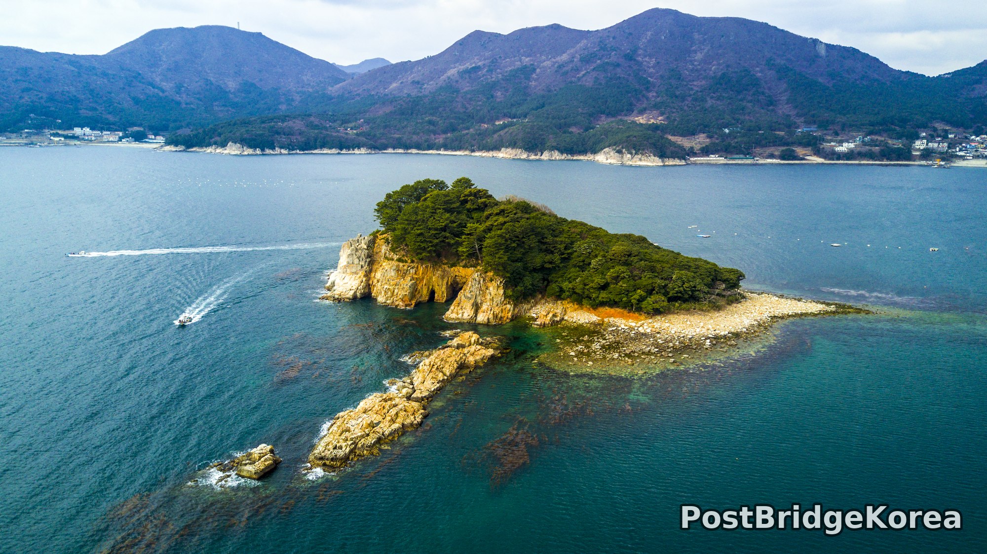
Early spring in Geoje is a strange, in-between moment. The hillsides have not fully greened up yet — the bare deciduous crowns still show that raw, purplish-brown that only lasts a few weeks before everything flushes out — and that seasonal ambiguity is exactly what gives these shots their geological clarity. From the ground you read the coastline as a shoreline. From above, what you actually see is something far more structural: a series of heavily fractured rock shelves and submerged reefs extending well beyond the visible cliff faces, their amber-stained surfaces cutting into deep-teal water like the exposed roots of a larger, mostly submerged landmass. The small islet in the first shot is a perfect example. Most visitors would describe it as a cute little island with trees on top. The drone tells you it is the highest point of a broad, flat reef platform. The shallow reef extending southward is almost as large as the island itself, and without the aerial vantage point you would never know it was there.
The light on the day of this shoot reads as overcast-bright: not golden hour, no hard shadow lines, no strong directional side-light. That kind of diffuse, grey-white sky is frustrating for drama but very useful for geological detail. The tonal range between the orange-brown rock, the dark green pine, and the steel-blue sea is wide enough to hold contrast even without direct sun. The cliffs on the larger headland — the second shot — show near-vertical stratification in the rockface, the kind of geological layering that only resolves at this look-down angle. And the formal garden in the third shot, seen straight down in a true nadir composition, would be completely illegible from anywhere below treetop height: the sinuous double-loop planting beds, the rows of rounded topiary, the amphitheatre-style structure at the near end — none of that geometry registers from the walking paths inside it. People always talk about aerial photography as a different perspective. From directly above this garden, it is the only perspective from which the masterplan makes sense as a designed whole.
Spatial Composition and Landmark Analysis: Foreground, Midground, Background

Photo 1 — Small rocky islet, wide-angle overhead:
– Foreground: The islet itself, with iron-stained amber cliffs, a natural sea cave visible in the rock face, dense pine canopy on the summit plateau, and a broad low-tide reef shelf extending south with scattered kelp visible through shallow turquoise water.
– Midground: A small motorboat crossing left of frame, its wake tracing a clean arc across the water surface; additional mooring buoys dotting the sea to the right.
– Background: A larger island or peninsula ridge with mixed forest and bare winter scrub; scattered low-rise buildings along the waterfront on both left and right margins.
Photo 2 — Headland cliffside, wide-angle oblique:
– Foreground: Severely fractured, vertically stratified sandstone or sedimentary cliffs dropping straight into deep-blue water; rock ledges at the base still exposed at low tide.
– Midground: The broad summit plateau of the headland, with a mix of dark pine stands, golden-brown open grassland, a road running roughly north-south across the plateau, and several multi-storey buildings including what appear to be guesthouses or small hotels along the left margin.
– Background: A communications or relay tower on the hilltop; additional smaller wooded islands to the right; mountainous ridgeline receding into haze on the left horizon.
Photo 3 — Formal garden, true nadir (straight-down):
– Foreground: The main axial promenade flanked by two parallel rows of spherically trimmed topiary; a long rectangular bed with sinuous interlocking planting loops running down the centre of the axis; an open semi-circular amphitheatre or viewing terrace at the near end.
– Midground: A red-roofed building (likely a visitor centre or administration building) to the right of the axis; geometric ornamental beds with circular and triangular motifs; winding perimeter paths disappearing into tree cover.
– Background: Dense mixed forest wrapping around the entire garden perimeter; two parallel greenhouse structures visible at the lower margin; scattered mature trees with early spring yellow-green foliage mixed with darker evergreen crowns.
Photo 4 — Cliffside rocky shoreline, nadir/near-nadir:
– Foreground: Deep-blue open water with white water breaking around scattered flat reef rocks; the reef rocks show the same amber-and-grey colouration as the main cliff.
– Midground: A heavily fissured cliff edge where the headland splits into two rock arms, forming a narrow sea inlet between them; wave wash visible in the channel.
– Background: Dense tree cover at the top of the cliff; two parallel greenhouse structures sitting at the cliff edge — the same greenhouses glimpsed from the garden shot, confirming these two locations are adjacent or connected.
Recommended Drone Camera Settings and Composition Tips for This Shooting Condition

Overcast-bright coastal light like this is deceptive. The sky acts as a giant softbox, which sounds ideal, but the sea surface still returns a significant amount of reflected light — especially with Geoje’s characteristically dark teal water — and if you expose for the sky your rocks go muddy, while if you expose for the rocks your sky blows out. For this kind of scene, an exposure compensation of around -0.3 to -0.7 EV is worth trying as a starting point, pulling the histogram slightly left to protect the highlight detail in the cliff faces and water surface. A CPL filter is a strong recommendation here: not primarily to deepen the sky (there is no blue sky to deepen under overcast conditions), but to cut surface reflection off the water and reveal the submerged reef structure visible in Photo 1. That turquoise-to-teal gradient around the islet is only possible when the polariser is dialled in correctly. Without it, the shallow reef reads as a uniform grey-white glare patch.
For the geological cliff shots — Photos 2 and 4 — the stratified rock texture benefits from maximum optical sharpness rather than any creative aperture work. An aperture in the f/5.6 to f/8 range is generally recommended for drone lenses at this kind of subject distance, keeping the whole scene in pan-focus without diffraction softening the fine rock detail. ISO should ideally stay at base (100 or 200 depending on the sensor), since the overcast diffusion provides plenty of ambient light even without direct sun. Dynamic range on these scenes is wide but manageable in that ISO range; shooting in a flat or D-Log profile and grading the orange-blue contrast in post gives you considerably more flexibility than trying to nail it in-camera.
Composition is where this site really rewards planning. The small islet in Photo 1 is a gift for one-point perspective: position the drone so the reef tail points directly toward camera and the island sits at the central vanishing point, letting the reef lines converge naturally. The formal garden in Photo 3 is already doing this for you — the axial promenade is a textbook one-point perspective line from the amphitheatre toward the red-roofed building, and the symmetrical topiary rows enforce it on both sides. For the cliff shots, diagonal composition works better: the fracture lines in the rock face run at roughly 30 to 45 degrees across the frame, and aligning the drone heading so those lines cut corner-to-corner rather than running parallel to the frame edge gives the image a sense of geological force. A three-layer framing approach — water, cliff, sky — with the horizon placed at the upper third line keeps the cliff mass dominant without the sky becoming dead space. Most people assume coastal drone shots need a lot of sky. From this vantage point, the geology is the subject, and the sky is just the lid on it.
Outdoor Drone Flight Safety and Regulatory Checklist for This Terrain and Season
Coastal headland flying in early spring brings a specific set of conditions that catch pilots off guard. The first is wind. Cliffs create updrafts and turbulent rotor wash at the cliff edges that simply do not appear on any weather app — the air 100 metres out from the cliff face can be calm while the air directly above the rock is churning. Watch the water surface and the pine canopy in your monitor carefully before committing to any position near a cliff edge; both are good real-time wind indicators, and the footage from this shoot shows relatively low surface chop, suggesting conditions were acceptable that day, but that can change fast in a coastal setting without warning.
Battery temperature matters more than most pilots acknowledge in early spring. March mornings in this part of South Korea can still be cold enough to reduce effective battery capacity noticeably compared to what a bench test shows. Keep batteries at body temperature before launch, and monitor cell voltage during flight rather than just the percentage readout. Set your RTH (return-to-home) altitude high enough to clear every ridge, cliffline, and tree stand between your position and the aircraft — in terrain like this, a default low RTH altitude will likely result in a very expensive collision with a pine-covered rock face.
The vision positioning sensors on most consumer drones struggle over water and over uniform rocky surfaces without strong texture contrast. Over the open sea sections of this shoot, GPS hold is reliable in calm conditions but should not be fully trusted at low altitude close to the water surface. Keep altitude margins conservative over open water. The greenhouse structures and cliffside garden buildings visible in Photos 3 and 4 indicate this is a managed site with infrastructure, which means flight permission from the site manager is something to arrange in advance rather than on the day. Separately, before any flight here, check an official airspace and no-fly-zone lookup for the specific coordinates — coastal and island areas in South Korea can fall under controlled or restricted airspace designations that are not obvious from a map view alone, and those designations can change. Check the day before, not a week before.
Leave a Reply