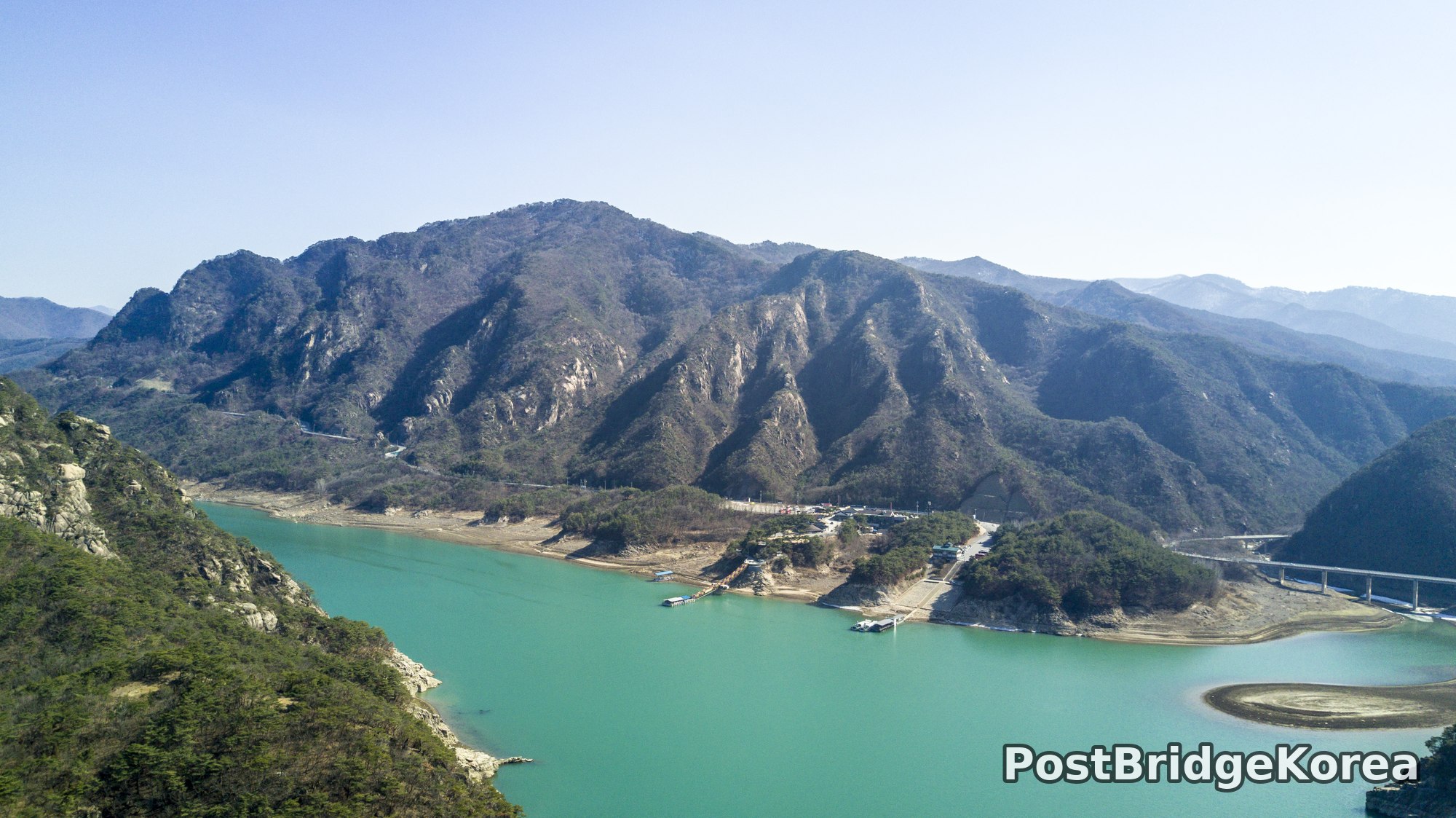

The Visual and Geological Value of Aerial Drone Photography at Danyang Palgyeong in Early Spring

The first thing on screen that morning was the water. That particular shade of jade-green, somewhere between glacial melt and old celadon, filled the monitor and honestly made me second-guess my white balance before I checked anything else. This was early March 2017, just at the cusp of spring, and the reservoir was still carrying the cold clarity of a Korean winter: low water levels exposing a wide pale band of bare rock along every shoreline, the deciduous trees stripped back to dark grey skeletons on the ridgelines, the pines holding their colour against everything around them.
From ground level, Danyang Palgyeong reads as a river gorge. From above, it becomes something else entirely. The aerial vantage reveals the full geometry of how these mountain ridges fold inward around the water, interlocking spurs of granite that create a series of natural chambers, each one curving the reservoir in a different direction. You cannot see this from any trail. The high-angle view also made the low water level work in our favour compositionally: the exposed white limestone bands act as natural leading lines around every bend, drawing the eye deep into the frame in a way that a higher water level, which would have submerged them, simply wouldn’t allow.
The sun that day was coming in at a relatively low arc for early March, throwing long directional shadows down the rock faces and across the ridge crests. Side-lighting at this angle does something extraordinary to striated granite cliffs. It cuts hard shadow into every vertical crack and joint, giving the stone a three-dimensional depth that flat midday light flattens out completely. People usually say spring is the best season here for the cherry blossoms and green growth, but from above, the bare-winter-to-early-spring window is genuinely more interesting geologically: the rock is exposed, the water is clear, the ridgelines are legible. The colours are muted and honest, and the dynamic range between the dark shadowed cliff faces and the reflective turquoise surface is wide enough to really push what a drone sensor can handle.
Spatial Composition and Landmark Analysis: Foreground, Midground and Background Across All Four Shots

Breaking down what is actually visible across these four frames:
FOREGROUND:
– Photo 1: The left-bank cliff face with exposed granite and pine trees clinging to the rock shelf, the near water surface in deep jade-green reflecting almost nothing in the harsh light
– Photo 2: The upper left ridge, a sheer granite wall with layered rock bands and scattered Korean red pine growing at extreme angles from the cliff face, dropping almost vertically into the reservoir
– Photo 3: The close-approach frame of a single vertical cliff section showing exposed columnar-jointed granite with Korean red pines growing from every ledge crack, the scale only readable because the tree trunks give a human reference
– Photo 4: A cluster of dark volcanic-looking rock pinnacles rising directly from the shallow reservoir floor mid-river, their jagged profile casting short shadows on the jade water around them, a small flat-bottom boat visible at the far left bank
MIDGROUND:
– Photo 1: A small developed area on a peninsula or river bend, a cluster of low buildings, what appears to be a small dock with a vessel moored, a road running along the water’s edge, and a sandy-coloured exposed spit of land jutting into the reservoir
– Photo 2: The main ridge mass, its upper granite cliff band now reading as a continuous wall, the tree line sparse and winter-bare except for pine patches, a tourist cruise boat tracking along the base of the cliffs on the right side of the water
– Photo 3: Secondary ridge peaks stepping back behind the foreground cliff, their rock faces carrying the same columnar-joint texture but in softer light
– Photo 4: The far bank rising steeply from the water with low scrub vegetation, and to the right, a moored houseboat-style vessel
BACKGROUND:
– Photo 1: A multi-span elevated highway viaduct visible in the right midground-to-background zone, the pale concrete columns standing out clearly against the dark hillside; multiple mountain ridges receding in atmospheric haze to the far distance
– Photo 2: Successive mountain ridges in deep atmospheric blue-grey, the furthest barely distinguishable from the sky
– Photo 3: Sky only, overexposed white with no detail, the cliff filling essentially the entire frame
– Photo 4: The same viaduct structure visible in Photo 1, here appearing across the upper frame as a long horizontal band of pale concrete, with flat agricultural lowland visible to the upper left and a small traditional-style pavilion visible at the base of the right bank cliff
Recommended Drone Camera Settings and Composition Tips for This Shooting Condition

For a high-contrast late-winter-to-early-spring scene like this, turquoise water against pale limestone and dark shadowed granite against bright sky, protecting highlights is the first priority. Exposure compensation in the range of -0.3 to -0.7 EV is generally recommended when the sky is this bright and flat: let the shadows go slightly dark rather than blow out the water surface, which is the key subject element. A CPL filter is strongly recommended for this type of water-over-rock scene. At the angles these shots appear to have been framed, the polariser would reduce surface glare and deepen the jade-green hue of the reservoir rather than letting it wash toward grey-white specular reflection, though the effective angle of polarisation on a rotating gimbal requires adjustment as the drone changes heading.
For aperture, somewhere in the f/5.6 to f/8 range is typically recommended for drone work over reservoir terrain where you need pan-focus from the near cliff face to the far ridge. Wider apertures risk softening the background ridges; smaller than f/8 risks diffraction softening on smaller drone sensors. ISO should ideally stay at base, ISO 100 on most consumer drone sensors, given the bright conditions visible here. The risk of noise is low, but the risk of highlight clipping on the water surface is real. Shooting in a flat or D-Log profile, if the drone’s camera supports it, gives more latitude to recover the dark shadow detail in the cliff faces during post without destroying the water highlights.
For composition: the one-point perspective technique works particularly well when the reservoir channel runs directly away from the camera, as in Photo 2. Positioning the water’s vanishing point on the upper-centre or upper-third of the frame, with the cliff wall filling the lower two-thirds, creates a strong three-layer framing, cliff foreground, water midground, ridge background, that reads immediately as depth. The diagonal of the shoreline rock band in Photo 2 is a textbook leading line; in post, rotating the frame slightly to align that diagonal from corner to corner sharpens the compositional energy considerably. For close cliff shots like Photo 3, a perfectly level horizon matters less than keeping the vertical joint lines in the rock genuinely vertical in frame. Tilted verticals on cliff faces look like lens distortion even when they are not.
Outdoor Drone Flight Safety and Regulatory Checklist for This Terrain and Season
Flying over water is one of those situations where the margin for error is exactly zero. A water landing is a total loss in almost every case. Before flying at any reservoir site in the Korean mountains, check the airspace status through an official airspace or no-fly-zone lookup resource before you leave home, not in the car park. Mountain reservoir areas can fall within controlled or restricted airspace, and proximity to dams and water infrastructure can carry additional restrictions that are worth confirming with the local site manager directly.
Early March battery performance deserves specific attention. Even if the air temperature during the day feels moderate, temperatures at altitude and over water drop faster than expected, and lithium polymer cells lose effective capacity measurably below 10°C. Keep batteries inside a jacket or insulated bag until the moment of insertion, and watch the battery temperature indicator on your ground station throughout the flight. A cell that shows 80% on the ground can drop to warning levels sooner than the software predicts in the cold. Set return-to-home altitude carefully before takeoff: the ridge profiles in these photos show that the terrain rises sharply on both sides of the water, so a low RTH altitude that would be fine in flat terrain could result in a collision with a cliff face on the return path. RTH altitude should clear the highest visible terrain feature around the flight zone with a meaningful margin.
Vision sensors on most consumer drones perform poorly over flat water. The featureless, reflective surface gives the downward positioning system nothing to lock onto, which affects hover stability and obstacle detection. Manual altitude hold or barometer-primary mode is advisable when hovering over the open reservoir. Never fly beyond line of sight over water in terrain this complex; the ridgelines block radio signal faster than open ground does, and any interruption that triggers an RTH from above the water needs a clear return path already planned. Finally, if the site has tourist boats operating, and both Photos 2 and 4 show vessels on the water, maintain enough altitude and lateral distance to avoid any conflict with their operations.
Leave a Reply