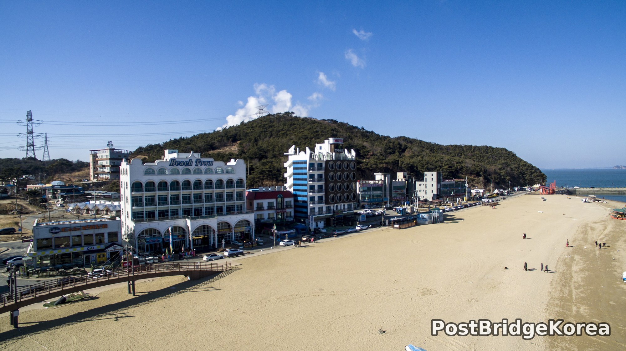

The Visual and Geological Value of Aerial Drone Photography at This Terrain and Season

The first thing on screen when I got airborne was the sand. Not the buildings, not the water — just how much flat, pale beach there was, and how the entire coastal strip clicked into a shape you simply cannot read from ground level. Waemok Village sits at the tip of a narrow peninsula on the Yellow Sea coast of South Chungcheong Province, and its defining geological feature, a curving tombolo, a sand bridge linking the headland to a forested offshore hill, is completely invisible when you’re standing on the boardwalk in front of Beach Town. From the air, it’s obvious in one glance.
The shoot date was February 12, 2017, deep winter. That matters for a few reasons. First, the sun sits low even at midday, which means side-light was almost certainly playing across the sand surface when I put the drone up. Low winter sun rakes across flat terrain and reveals texture, ripple marks, tire tracks, the long shadows of utility poles, in a way that flat summer noon light completely erases. The sky in both frames is almost cloudless and deeply blue, a quality the cold dry air of a Korean winter tends to produce far more reliably than any other season. Haze is minimal. Contrast is high. That combination is genuinely useful for aerial work because the water reads as a distinct tonal value against the sand, and the forested hill behind the beachfront strip shows as a clean dark mass against the pale blue above it.
People often say winter is the wrong time to shoot Korean beaches, off-season, low crowds, nothing happening. From above, the opposite is true. The empty beach in the first frame becomes a compositional asset, a broad diagonal plane that leads the eye directly into the midground, and the absence of summer parasols and tents means the actual geometry of the site, the road, the buildings, the hill, the water edge, is legible with no visual clutter. The second frame, shot from a higher altitude looking seaward, is the more dramatic of the two: the tombolo curves out like a brushstroke into the Yellow Sea, with aquaculture frames visible in the right-hand water and small islands dissolving into the haze on the horizon. That image would not read the same in any season that puts boats, crowds or turbid summer water into the frame.
Spatial Composition and Landmark Analysis: Foreground, Midground and Background
Both frames are from the same site but taken from clearly different altitudes and orientations. Breaking them down together gives a complete spatial map of what Waemok looks like from the air.
Frame 1 — Beach-level oblique, looking roughly northeast along the shoreline:
– Foreground: Wide expanse of flat tidal sand occupying roughly the lower two-thirds of the frame; a wooden elevated boardwalk or observation deck structure visible at the lower-left edge; a few scattered pedestrians on the beach providing scale.
– Midground: The beachfront commercial strip running parallel to the shore — the most prominent building is the white arched-facade structure with “Beach Town” signage, a multi-storey building with Moorish-style arcade windows on the ground floor; immediately to its right is a taller mixed-use building with a distinctive circular-window or porthole facade; a hotel building farther right; ground-floor retail units including a CU convenience store visible at street level; parked vehicles along the road between buildings and boardwalk; a red harbour crane or loading structure visible near the waterline at the far right edge.
– Background: A densely forested conical hill rising directly behind the commercial strip, its ridge carrying a high-voltage electricity transmission tower and lines; the hill drops to meet the sea at the right edge where a small harbour entrance is visible; open Yellow Sea water beyond the hill under a clear winter sky.
Frame 2 — High-altitude overhead oblique, looking seaward from above the wooded headland:
– Foreground: The top of a forested high point (the headland bluff) occupying the lower centre of the frame, pine trees identifiable by their dark canopy colour.
– Midground: The tombolo — a curving, narrow sand spit connecting the headland bluff in the foreground to a second forested island mass farther out to sea; the sand strip is pale and clearly defined against the blue-grey Yellow Sea water on both sides; a small settlement with white-painted buildings and a pier or harbour breakwater is visible on the far island at the end of the sand bridge; a white lighthouse structure is identifiable near the harbour.
– Background: Open Yellow Sea extending to the horizon; a grid of aquaculture frames (likely seaweed or shellfish cultivation) visible in the upper-right water area; at least two additional small rocky islands scattered in the left-mid distance; faint outlines of further islands and what appears to be a cargo vessel on the far horizon.
Recommended Drone Camera Settings and Composition Tips for This Shooting Condition
Winter midday light over a pale sand beach is one of the more demanding exposures you’ll encounter in coastal drone work. The problem is dynamic range: the sand reflects a huge amount of light, the water is moderately dark, and the forested hill is darker still, all three sitting in the same frame. For this type of scene, a starting exposure compensation of around -0.3 to -0.7 EV is worth trying to protect highlight detail in the sand without pushing the shadows on the hill into full black. Check your histogram before committing to a long sequence. Clipping the white sand is far more destructive to the final image than slightly underexposing the tree line.
For aperture, something in the f/5.6 to f/8 range is generally sensible for aerial coastal work in bright winter conditions. You want pan-focus across the full depth of scene, from the foreground sand through to the distant water, and the small sensors on most drone cameras achieve that most cleanly in this aperture band rather than at the fully open end. ISO should stay at base, typically ISO 100, in full winter daylight; there is no reason to lift it here. A CPL filter is worth serious consideration for the second type of shot, the high-altitude seaward frame where you’re looking down at water at varying angles. A circular polariser can cut surface glare, deepen the blue of the water and make the aquaculture grid structures read more clearly against the sea. It won’t help much for the beach-level oblique where the light angle is less favourable for polarisation.
On composition, the tombolo shot in Frame 2 is a textbook case for one-point perspective alignment: position the drone so the sand bridge runs from the near foreground to a visual convergence point at the far island, with equal water on both sides. That vanishing-point alignment draws the eye through the entire frame. For the beachfront shot in Frame 1, the diagonal of the shoreline is your strongest tool. The standard approach is to place the beach edge along the lower third of the frame and let it run corner to corner, using the building strip as the middle horizontal band in a three-layer composition, sand below, buildings across the middle, hill behind. Shooting with the winter sun behind or to the side of the drone, rather than directly into it, will preserve shadow detail on the building facades and make the “Beach Town” signage legible rather than blown into white.
Outdoor Drone Flight Safety and Regulatory Checklist for This Terrain and Season
Coastal peninsula terrain like this has a specific set of hazards worth thinking through before you power on. The water is on three or four sides depending on where you’re positioned, and if you lose orientation or trigger an unplanned RTH from the wrong spot, a water landing is a real outcome. Set your RTH altitude before takeoff. It needs to clear the forested hill visible in both frames, not just the buildings. From the beach-level position in Frame 1, that hill behind the commercial strip is the dominant obstacle and it’s higher than it might initially appear when you’re standing on flat sand looking along the shore.
Winter coastal conditions add battery management as a genuine constraint. Cold air reduces lithium battery capacity noticeably, how much depends on the specific battery, so pre-warming batteries to operating temperature before flight and monitoring cell voltage through the flight app are standard precautions, not optional ones. Plan to land earlier than the low-battery warning if the air temperature is significantly below 10°C. The Yellow Sea coast can also produce unexpected wind gusts even on days that look calm at ground level; the clear sky in these frames doesn’t tell you what the upper-air wind was doing. Check wind forecasts at the altitude you plan to fly, not just surface conditions.
Regulatory compliance at Waemok means checking the airspace status before every visit, not just once. Coastal and island-adjacent areas around the Yellow Sea can carry restricted or controlled airspace designations that are not always immediately obvious from a map, and the status can change. Use an official airspace and no-fly-zone reference before flying and, if the site involves any managed land, harbour areas, national park designations, proximity to populated beach facilities, confirm with the site manager on the day. No camera shot is worth the legal and safety exposure of skipping that step. Visual-line-of-sight rules apply; the tombolo geometry in Frame 2 is visually appealing precisely because it extends far out to sea, and it is easy to let the drone drift farther than intended while chasing that composition.
Leave a Reply