
The Visual and Geological Value of Aerial Drone Photography at Danyang Palgeyong in Early Spring

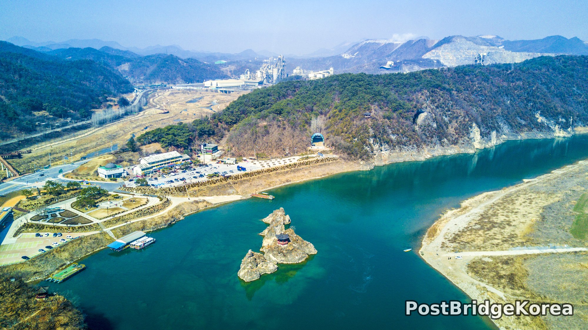
The first thing on screen when I lifted off was colour. Not green — not yet — but that particular shade of glacial turquoise that the Namhan River reservoir throws back at a clear March sky, hard and cold and almost unreal. People who visit Danyang on foot almost never see this. From ground level the water just looks wide. From the air, the full geometry of the reservoir’s S-bend opens up in a single frame, and you understand immediately why the rock formations in the middle of it have been celebrated for centuries.
The shoot date was March 4th, which sits right on the hinge between winter and spring in this part of Korea. The hillsides are still bare. The deciduous trees are brown and skeletal, their canopy stripped back to nothing, which is actually a gift to aerial photographers. No leaf cover means the limestone ridge lines and the quarry-scarred mountain faces in the background are fully exposed. The pale stone on the ridge to the upper right of the wide overview shot creates a tonal contrast against the darker pine stands that you simply lose once the trees flush out in April. Shoot this place too late in the season and the rock loses its drama.
Side-lighting from a low winter sun rakes across the jagged rock outcrops sitting in the reservoir, throwing hard shadows to one side and picking up every texture on the limestone surface. That same low-angle light gives the water its depth of colour by hitting it obliquely rather than washing it flat the way a summer midday sun would. The aerial vantage point is what seals the deal: the vertical drop from drone height lets you see the submerged rock shelves glowing through the clear shallow water around the island clusters, a detail that is simply invisible from the ferry or the shore. From directly above, the largest island reads almost like a brushstroke — elongated, curved, with a traditional Korean pavilion sitting on its narrowest ledge like a punctuation mark someone placed there deliberately.
Spatial Composition and Landmark Analysis: Foreground, Midground and Background Across All Four Shots

Breaking this location down spatially across the four photos:
FOREGROUND
– The cluster of limestone rock islets rising directly from the reservoir surface, the most compositionally dominant element in all four images
– A traditional Korean-style pavilion with a dark-tiled, multi-eaved roof, positioned on a low ledge of the largest islet — visible as a red-and-black structure in the angled shots and as a grey striped octagonal roof from directly overhead
– Shallow submerged rock shelves surrounding the islets, clearly visible through the turquoise water in the nadir (straight-down) shot, creating a halo of pale underwater geology around the exposed rock
– Two or three satellite islets — one tall and spire-like to the left, one lower and rounded to the right — flanking the central formation
MIDGROUND
– A tourist ferry boat moored at a small dock on the left (western) bank, with a second ferry visible underway in the reservoir gorge shot, its wake a clean white V on the turquoise surface
– The visitor centre and service buildings along the left bank: a multi-building complex with parking bays, including a domed roof structure and a larger flat-roofed commercial building
– A road network running along the left bank, including a major elevated highway bridge (with blue parapets) spanning the reservoir just behind the rock islands
– A cable car station and tunnel portal cut into the cliff face on the right (eastern) bank, with the cable car gondola partially visible against the rock face
– Sandy low-water beaches exposed along both banks, evidence of the reservoir sitting below its maximum winter level
BACKGROUND
– A large industrial cement plant complex in the valley behind the left bank, with processing towers, conveyor structures and white dust visible on the adjacent quarried hillside
– Multiple ridge lines of forested mountains retreating into haze — pine-covered lower slopes, bare upper ridges, and at least one heavily quarried white limestone face on the right background ridge
– A winding mountain road visible on the right gorge wall, cut as a narrow single lane into the cliff face
– The reservoir gorge continuing deep into the mountain valley, narrowing in the distance with the walls closing in on both sides — the second photo captures this perspective most clearly, looking up-river from low altitude
Recommended Drone Camera Settings and Composition Techniques for This Shooting Condition

For a scene this high in contrast — white limestone, near-black rock shadow, turquoise water and a pale hazy sky all in the same frame — dynamic range management is the first decision to make before the drone even takes off. I shoot in RAW and dial in a slight negative exposure compensation, somewhere in the range of -0.3 to -0.7 EV, to protect the highlight detail in the pale limestone faces and the bright sandy bank areas. Letting those whites clip in-camera is hard to recover in post, whereas pulling shadow detail back from a slightly underexposed RAW file is straightforward.
For aperture, a value around f/5.6 to f/8 is generally recommended for this type of wide aerial scene. It keeps the entire frame in pan-focus without introducing diffraction softness, which becomes noticeable on smaller drone sensors beyond f/9 or f/10. ISO should ideally stay at the camera’s base value — typically ISO 100 on most current aerial camera systems — given the bright midday or late-morning light apparent in these images; there is no need to push sensitivity here. A CPL filter is strongly worth considering for this specific location. The polariser cuts surface glare on the water, deepening the turquoise colour considerably and making the submerged rock shelves visible through the surface. That is exactly the effect you can see in the nadir shot, which is one of the most compelling images in the set. People usually say the pavilion is the main subject here, but from above it’s the underwater geology that earns the longest look.
For composition, the nadir shot of the rock islands rewards a strict geometric read — centre the largest islet mass and let the smaller satellites create an asymmetric counterbalance. For the angled shots, a one-point perspective looking up the reservoir gorge, as in the second photo, works because the valley walls act as converging lines pulling the eye toward the vanishing point deep in the mountains. The three-layer framing — rock islands up front, ferry and buildings in the middle, mountain ridges behind — is ready-made here; the only real decision is how much sky to include given the haze. On a day like this one, keeping sky to roughly the upper quarter of the frame lets the terrain and water dominate, since the haze carries very little tonal information and softens contrast toward the top of the frame anyway. For the elevated overview shot, aligning the curved arc of the reservoir’s nearside bank along a diagonal from lower-left to upper-right gives the composition a natural flow that follows how the eye reads a frame.
Outdoor Drone Flight Safety and Regulatory Checklist for This Terrain and Season
A site like this — a reservoir gorge with steep mountain walls on both sides, an industrial facility nearby, an active tourist area with ferry traffic and a cable car system, and a highway bridge spanning the water — has a lot going on from a risk and airspace standpoint. Check before you fly: look up the local airspace classification and any flight restriction zones using an official airspace resource before you go anywhere near the launch point. Reservoir and river zones sometimes carry specific restrictions, and the proximity to infrastructure like bridges and cable cars means Return-to-Home (RTH) altitude needs to be set well above the highest obstacle in the area before takeoff, not estimated after the fact.
In early March the temperatures in inland mountain valleys like this can still drop sharply, especially in morning shade. Cold batteries lose usable capacity fast — sometimes significantly faster than the manufacturer’s rated flight time suggests. Warming batteries to operating temperature before inserting them, and monitoring the in-app cell voltage throughout the flight rather than relying purely on percentage readouts, is standard cold-weather practice. Landing early is cheaper than fishing a drone out of a reservoir.
The water surface and the pale limestone rock faces both create challenging conditions for vision-positioning systems. Featureless reflective water gives downward-facing optical sensors very little to lock onto, and textured white rock can confuse obstacle-detection cameras by creating false depth readings. In this kind of terrain, relying on GPS positioning rather than vision-assist mode near the water surface, and maintaining adequate altitude over open water, is the cautious approach. Wind can behave unpredictably in gorge terrain — the valley walls channel and accelerate airflow in ways that are not apparent from ground level, so watch the drone’s attitude indicator carefully in the first few seconds after takeoff and be ready to abort if the aircraft is fighting the conditions harder than expected.
Always carry a printed or screenshotted copy of any airspace authorisation you have obtained, and brief yourself on emergency landing options before you launch. On this shoot, the sandy low-water beaches visible along both banks would be the most practical contingency landing zones if a return-to-home became necessary.
Leave a Reply