
The Visual and Geological Value of Aerial Drone Photography at This Terrain and Season

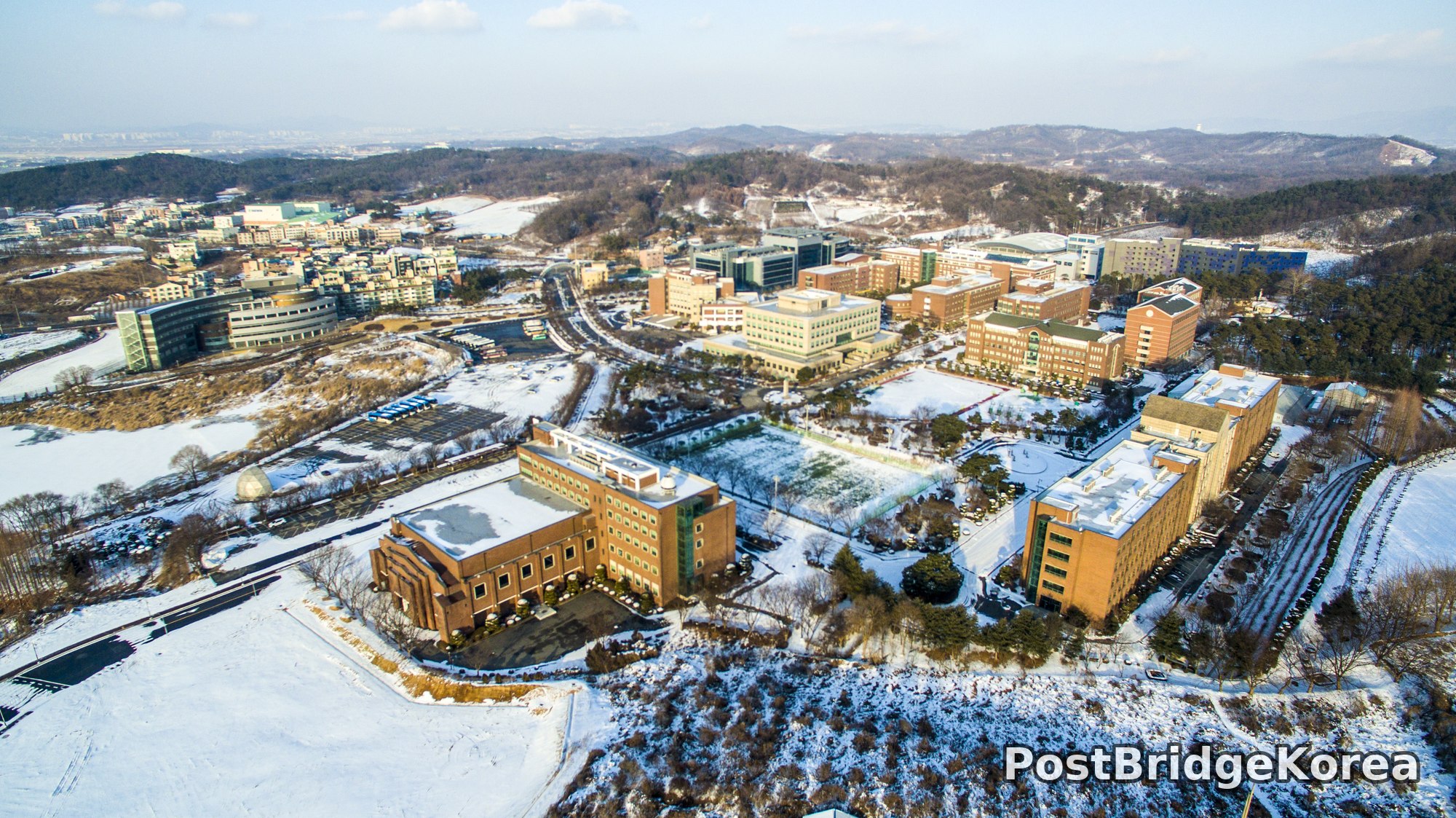
The first thing on screen was white — flat, unbroken white — and then, as the drone climbed, the warm terracotta grid of the campus buildings punched through it with an almost cartographic clarity you simply cannot read from ground level. January snow at Cheonan Seonghwan does something useful for aerial photography: it erases visual noise. Roads, parking lots, field edges — all the clutter that makes a campus look chaotic on foot — disappears under a uniform layer, and what remains is pure massing. You see the masterplan.
The low winter sun on January 22nd threw long, raking shadows across every rooftop and courtyard. Side-lighting like that is exactly what reveals topography, and here it sculpted the gentle hillside contours behind the main campus cluster into something that reads almost three-dimensional from above, the tree-lined ridgeline casting blue-grey shade down the slope. People often assume campus aerial shots are architectural documentation. From up here, though, it reads far more like a land-use diagram. The relationship between the built campus and the surrounding agricultural fields and hills to the north becomes immediately obvious in a way no campus map ever quite conveys.
The two nadir shots from this session are the real find. A frozen pond, its surface broken by the dark silhouettes of submerged or emergent vegetation poking through the snow, produces a composition that looks closer to abstract printmaking than outdoor photography. The snow-capped junipers clipped into domes, photographed directly overhead, turn into a pattern of spheres casting paired shadows — the kind of geometric repetition that a ground-level lens physically cannot see. Winter strips away colour and what it leaves is structure. That’s the argument for flying in January.
Spatial Composition & Landmark Analysis: Foreground, Midground, Background

Across all four images, the campus reads in three distinct spatial layers. Here is how the scene actually breaks down:
Foreground:
– Snow-covered open ground and dormant vegetation immediately below and around the drone, including bare-branched deciduous trees fringing the campus edges
– The frozen pond with dark organic shapes piercing the snow surface — visible in the nadir pond shot as an archipelago of ice-free or snow-stripped plant clusters, likely reed or aquatic grass stands
– A cluster of dome-shaped clipped junipers photographed from directly overhead, their rounded crowns dusted with snow and casting long low-sun shadows across the white ground
– Agricultural or nursery plots with grid planting, visible in the lower-left foreground of the high oblique shot showing the campus from the south-west
Midground:
– The main academic building cluster: multi-storey brick-faced blocks arranged around internal courtyards and open plazas, some with green-accented facades, one with a distinctive domed observatory element visible on its roof
– A large curved-roof auditorium or sports hall — its snow-loaded barrel vault is one of the most readable shapes from above, sitting centrally in the third image
– Interconnecting campus roads forming a clear spine running roughly north-south through the complex, flanked by tree-lined walkways
– Surface parking areas distributed around the building perimeter, their grid of car bays still legible under partial snow cover
– A second, architecturally distinct building cluster visible in the south-west oblique shot — lower-profile blocks with flat roofs and darker cladding, separated from the main brick campus by a tree belt
Background:
– Low wooded ridgelines to the north and north-east, their south-facing slopes showing patches of bare brown earth between snow-loaded evergreen canopy
– The wider Seonghwan city fabric spreading to the east and south-east — mid-rise residential blocks, commercial strips and roads becoming hazy at the horizon
– Open snow-covered agricultural flatland extending to the west and south, the fields reading as large blank rectangles in the distance
– A pale hazy sky with high thin cloud giving the horizon a soft, milky glow in the third image — the low sun position suggests this shot was taken in the mid-to-late morning, with the light source somewhere to the south-east behind the camera
Recommended Drone Camera Settings & Composition Tips for This Shooting Condition

Snow scenes destroy auto-exposure. The camera’s metering reads all that white and underexposes, and you get grey snow and muddy bricks instead of the clean contrast actually in front of you. For high-contrast winter scenes like this — warm-toned buildings against bright snow under a pale sky — starting with a positive exposure compensation of around +0.7 to +1.0 EV as a baseline makes sense, pulling it back slightly if the snow surface starts clipping in the histogram. Watch the highlights obsessively. Once snow blows out, it’s gone.
For the oblique wide shots, an aperture in the f/5.6 to f/8 range is worth considering to keep full depth of field across foreground features and the distant ridgeline — this is pan-focus territory, where you need everything from the courtyard below to the wooded hills sharp. ISO should stay as low as the light allows, ideally at the sensor’s base ISO (commonly 100), since the dynamic range demand in snow-versus-shadow scenes is already pushing the sensor hard. A CPL filter can help manage glare off snow surfaces and rooftops, though in flat overcast-leaning winter light its effect will be more subtle than in summer. ND filters are less critical when shutter speed is already constrained by the need to keep ISO down.
For composition, the one-point perspective works exceptionally well along the campus spine road — positioning the vanishing point centrally and letting the building facades line up either side gives a sense of designed order that mirrors the campus masterplan. The nadir shots in this set already demonstrate the payoff of committing to a pure top-down angle: do not hover at 45 degrees for these subjects. The frozen pond and the juniper dome cluster only reveal their graphic quality when the gimbal is tilted fully to 90 degrees. For the high oblique campus shots, a three-layer framing approach — foreground vegetation, midground buildings, background hills — gives the image a sense of depth that a single-layer composition simply lacks. Shoot when the sun is low enough to cast directional shadows across the rooftops; those shadows are doing a lot of the three-dimensional work in these images.
Outdoor Drone Flight Safety & Regulatory Checklist for This Terrain and Season
Cold weather is the single biggest operational variable in winter drone flying, and it shows up in one place first: battery performance. Lithium polymer cells lose usable capacity significantly as temperature drops, and a battery that reads 100% on a warm bench can behave like a 70% battery at genuine sub-zero field conditions. Pre-warming batteries to operating temperature before flying in winter conditions like these is sensible practice, as is monitoring voltage drop in real time during the first minute of flight. Shortening planned flight times and setting conservative low-battery return-to-home (RTH) thresholds is general best practice for cold-weather operations.
The terrain in these images involves a frozen pond and snow-covered open ground — both surfaces that confuse downward-facing vision-positioning sensors. Snow and ice have very low visual contrast, which can cause optical flow systems to lose position hold at low altitude. Over the frozen pond in particular, the sensor has almost nothing to lock onto. Setting a safe RTH altitude that clears the building rooflines and tree canopy around the campus perimeter — visible in the photos as a meaningful obstacle height — is worth calculating before takeoff rather than accepting the default value.
Before flying at any campus site, standard good practice is to contact the site manager or facilities office to confirm that drone operations are permitted on that day and in that area. Separately, check airspace status through an official airspace information lookup before every session — university campuses located near urban areas may sit within or adjacent to controlled or restricted airspace that requires prior coordination. These checks apply even if the site looks open and quiet. The combination of a large open snow-covered campus, nearby residential development, and wooded terrain at the perimeter means visibility and obstacle clearance demand genuine pre-flight attention rather than a quick glance around on the ground.
One cold-weather detail that often gets skipped: prop wash can kick loose surface snow into the motor housings at low hover altitude, especially over the kind of light powder visible in these images. A smooth, steady ascent from a cleared launch point — rather than hovering at half a metre while you adjust settings — keeps debris out of the motors and the camera lens clear for the first frame.
Leave a Reply