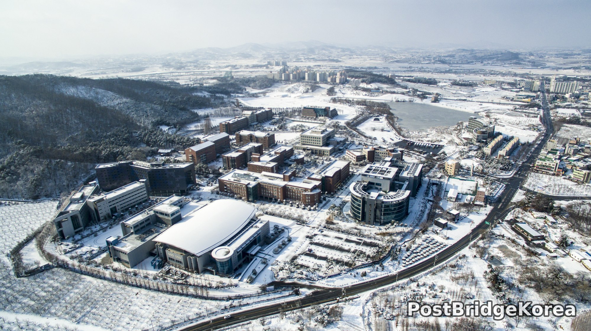

The Visual and Geological Value of Aerial Drone Photography in This Terrain and Season

There is a particular cruelty to winter drone photography in Korea’s central inland regions. The sky flattens out, shadows lose their drama, and the whole scene risks reading as a grey smear from above. January 30th at Nam Seoul University’s Cheonan Seongwhan campus proved the opposite. The overcast dome acted like a giant softbox, stripping out the harsh midday contrast that would normally blow the snow whites into featureless patches and crush the dark brick buildings into silhouettes. What replaced it was a tonal range wide enough to hold both at once: the cream of the domed auditorium roof sitting calmly beside the deep red-brown of the academic buildings, all mapped out in one uninterrupted frame.
From ground level, a campus like this reads as a series of connected corridors, entrances, and small courtyards. You never really grasp how it all fits together. From the air, the masterplan logic clicks into place instantly. The campus occupies a curved ridge between a forested hillside to the west and a boundary road to the east, and that curvature — which you’d never notice walking through — becomes the dominant geometry of the whole composition. The snow is not just decorative here. It functions as a high-contrast reveal tool, filling every flat roof, every parking bay, every terraced slope and orchard row until the campus reads like a white-ink architectural drawing on a grey ground.
Phone photos from the ground genuinely cannot compete with this. I know that frustration well, standing somewhere remarkable and watching every frame collapse into a confused mid-distance muddle. The aerial perspective solves it not by zooming out but by changing the angle of incidence: the flat-lit winter snow becomes a self-mapping surface, drawing every building footprint, every pathway, every frozen reservoir edge in stark relief against the surrounding terrain. The soft diffused light that winter cloud provides also means the dynamic range demand on the sensor is lower than on a clear sunny day, which, counterintuitively, makes overcast winter shooting one of the technically more forgiving conditions for campus aerial work.
Spatial Composition and Landmark Analysis — Foreground, Midground, and Background

Across all four frames from this shoot, the campus organises itself into three readable depth layers. The vantage points shift — two shots favour a south-to-north look, one pulls back to reveal the frozen reservoir to the south-west, and the fourth swings to show the western hillside — but the same structures appear consistently enough to anchor the full layout.
Foreground (lower third of each frame):
– The large curved-roof auditorium or gymnasium building dominates the southern foreground in the overhead shots — its smooth white dome shape is the single most visually distinct structure on campus and anchors every vertically-inclined composition
– A multi-storey building with a dark blue-tinted cladding panel appears in the south-west foreground of the fourth (south-facing) frame, partially embedded into the slope of the western juniper-and-juniper-covered hillside
– Snow-covered terraced agricultural plots — likely orchard rows given their regular grid spacing — fill the lower foreground corners in the wider shots, providing texture against the flat white ground
– The curved boundary road runs along the eastern edge of the campus from the bottom-right foreground toward mid-frame, acting as a hard compositional dividing line between campus and the surrounding town
Midground (centre mass of the campus):
– A cluster of red-brick academic buildings of varying height occupies the central campus zone — these appear consistently across all four shots and form the visual mass of the institution, their warm brick tone contrasting cleanly against the snow
– A cylindrical or elliptical glass-and-steel building sits at the eastern midground edge of the campus, its rounded modern form clearly distinct from the rectilinear brick blocks around it
– Internal campus roads and snow-covered parking areas create legible grid lines between buildings, reinforcing the masterplan structure from above
– A smaller isolated building with a dome or rounded roof sits deeper in the midground on the northern side of the main cluster, visible in the wider north-facing shots
Background (upper third, extending to horizon):
– A frozen or near-frozen reservoir body of water appears prominently in the background of the third shot and partially in others — its grey-green ice surface sits between the campus and the distant town buildings, adding a strong horizontal mid-tonal band
– Low-rise commercial and residential town buildings extend across the eastern background, their density increasing toward the right side of frame where the main road network and urban fabric of the surrounding area are visible
– A band of snow-covered low mountains and forested ridgelines closes the horizon in every direction, the western ridge being closest and most detailed — these hills provide the scene’s natural depth cue and give the entire composition its sense of enclosed valley topography
– Distant mid-rise apartment blocks, likely part of the broader Cheonan Seongwhan area, appear as pale vertical forms on the far horizon, grounding the scene in its regional urban context
Recommended Drone Camera Settings and Composition Tips for This Shooting Condition

Flat overcast winter light over a snow-covered campus is one of those conditions where the sensor’s dynamic range is actually on your side, but only if you handle exposure carefully from the start. For this type of scene, I’d recommend setting exposure compensation to between -0.3 EV and -0.7 EV relative to the drone’s metered baseline. Snow-dominant frames fool every metering system into underexposing, but overcorrecting will clip the dome roof and parking areas into featureless white. A conservative negative offset, checked against the histogram, is the safer starting point. Keep ISO at or near base value, typically ISO 100 on most current prosumer camera drones. The flat diffused light is bright enough that noise management is not the priority; preserving fine detail in the snow texture and brick shadow areas is.
For aperture, a mid-range f-stop in the f/5.6 to f/8 range suits this kind of expansive campus aerial work. Pan-focus across the full depth of the scene, from the auditorium dome in the foreground to the distant mountains, is what you’re after, and a wide-open aperture sacrifices that depth coverage for no meaningful gain in a bright ambient environment. A circular polarising filter would be worth considering if the reservoir ice or any wet roof surfaces are showing unwanted specular glare, though in flat diffused conditions its effect is reduced compared to direct sunlight. An ND filter is not needed here unless you are shooting video and need to lock a specific shutter angle.
On composition: the boundary road curving along the eastern edge of the campus is a natural diagonal leading line that pulls the eye from the bottom-right corner toward the building cluster. Positioning it along a thirds-line rather than centring it gives the frame more tension. For the overhead shots looking straight down or at a shallow tilt, one-point perspective works well with the auditorium dome as the anchor, letting the surrounding rectilinear buildings recede toward a single convergence zone. People usually say nadir shots flatten everything into abstraction, but from above a snow-covered campus the geometry reads more clearly than at any other angle. The three-layer framing approach, foreground snow texture, midground brick building cluster, background mountain ridge, is already inherent in this terrain and well worth reinforcing deliberately: tilt the camera to include all three bands rather than collapsing the shot into a pure nadir. Highlight clipping is the single biggest technical risk in this type of scene. Checking live histogram or zebra patterns against bright roof and snow areas before committing to a flight path will save a significant amount of post-processing pain.
Outdoor Drone Flight Safety and Regulatory Checklist for This Terrain and Season
Cold-weather battery performance is the first thing to account for before any winter flight. It is also the one pilots most consistently underestimate. LiPo and LiPo-derivative batteries used in consumer and prosumer drones lose usable capacity meaningfully at low temperatures, the effect becoming significant below around 10°C and worsening further below zero. Before flying in January conditions like those visible in these shots, keep batteries at operating temperature using an insulating pouch or indoor storage until just before launch, and warm them briefly through a few gentle hover seconds before committing to any demanding flight path. Watch the battery percentage more conservatively than you would in summer. Setting a return-to-home threshold higher than the default is a sensible precaution, and do not fly the battery down to an unusually low percentage.
The terrain here, a campus on a curved ridge between forested hillside and open snow fields, creates specific hazards for obstacle avoidance sensors. Snow-covered flat surfaces can confuse downward-facing vision sensors into misreading altitude, particularly on final descent. Manual altitude control or a conservative automated landing approach above a known clear surface is advisable. The western hillside tree cover adds an obstacle profile that is partially obscured by snow, so maintaining a clear visual line of sight and a generous RTH altitude above the tallest visible ridge is recommended throughout the flight.
On the regulatory side: before flying at or near any university campus, check with the institution’s management or facilities office that drone operations are permitted on the grounds. Separately, use an official airspace and restricted-zone lookup resource before launching. Campus locations near towns, roads, and infrastructure can fall within controlled or restricted airspace zones that are not immediately obvious on-site, and that is the kind of thing best sorted before the drone ever comes out of the bag. The frozen reservoir visible in these frames adds one more consideration: do not fly over or near open water or ice surfaces without confirming that your RTH altitude clears all intervening obstacles. A ditching over a frozen body of water in January presents obvious recovery complications, and that is not a scenario worth testing.
Leave a Reply