
The Visual and Geological Value of Aerial Drone Photography in This Terrain and Season

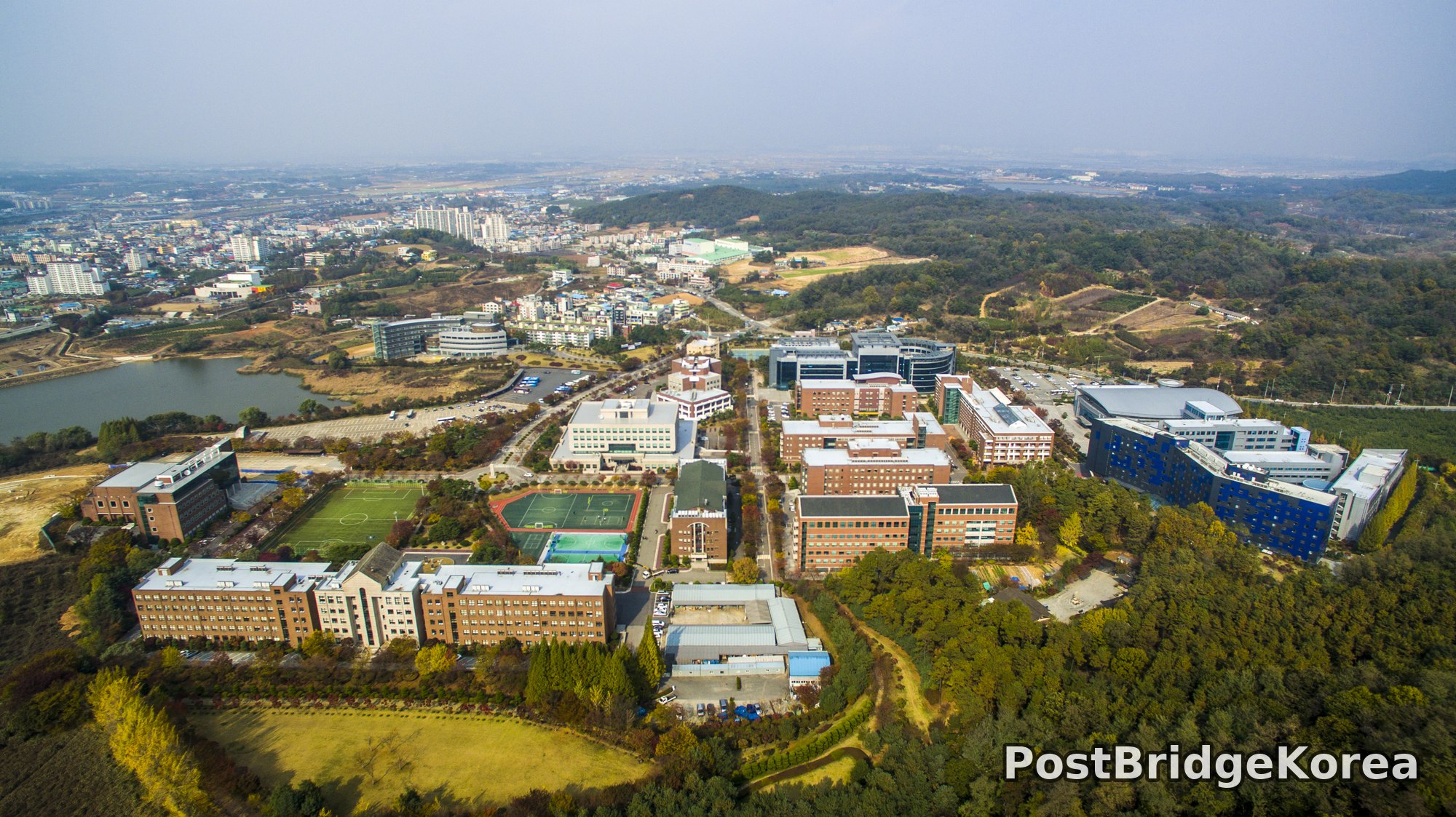
The first thing on screen when I pulled the drone up over Namseoul University’s Seongghwan campus in early November 2016 was how completely the forest hides the place at ground level. You would walk the perimeter road and have almost no idea of the scale inside. From above, it opened up immediately: a compact academic masterplan pressed into a shallow ridge bowl, with dense mixed woodland wrapping three sides like a cupped hand. That containment is invisible on foot. It only reads from the air.
The autumn light that day was doing exactly what side-angle November sun does in central Korea — casting long, low shadows off the east-facing building facades and picking out warm amber in the ginkgo and oak canopy. The sky had a thin haze layer, which actually helped. Hard-blue skies create blown highlights on white rooftops that compress your dynamic range badly. The soft diffusion from that upper-atmosphere haze kept contrast manageable across the whole frame, and the warm tones on the brick buildings read cleanly against the grey roofing. People often say flat light is boring, but from above a campus of mixed brick and glass, it is frequently kinder than midday directional sun.
Geologically, the site sits where a modest ridgeline transitions to flatter peri-urban land, and that gradient is exactly what aerial photography reveals so well. The first wide-altitude shot shows the campus spine running roughly north-south, the sports fields on the western slope, and the reservoir to the northwest glinting flat and grey — a strong tonal anchor in the upper-left of the composition. The surrounding Cheonan Seongghwan urban grid visible on the horizon gives the campus its sense of scale. You simply cannot communicate that spatial relationship between institution, ridge, water and city in a single ground-level photo. The drone earns its keep in one frame.
Spatial Composition and Landmark Analysis: Foreground, Midground, and Background

Across all three photos from this shoot, the campus organises itself into a legible three-layer structure that rewards careful reading. Here is the breakdown:
FOREGROUND
– Photo 1 (high north-looking shot): The long, flat-roofed dormitory or academic block running east-west across the lower frame, backed immediately by dense autumn woodland with amber and ochre foliage — the tree mass creates a natural base layer that grounds the entire composition.
– Photo 3 (mid-altitude close pass): The circular forecourt with low sculptural planting at its centre, the main entrance staircase and vehicle approach road in deep red-brick paving, and the multi-use sports pitch (green artificial turf, football markings) in the lower-left — autumn red maples and trimmed junipers punctuate the building base.
MIDGROUND
– Photo 1: The central campus spine with the main administrative/academic building visible by its arched classical entrance gable — brick construction, six storeys, the only building on campus with that distinctive pitched stone gable element — flanked by smaller pavilion-scale structures and internal parking courts.
– Photo 2 (high south-facing wide shot): The bold blue-panelled contemporary building complex dominates the western midground, and next to it the large domed/barrel-vaulted sports arena with its silver curved roof — the two together create the strongest architectural contrast on campus, old brick versus new glass and metal cladding.
– Photo 3: The main administrative building fills the entire midground — the arched entrance portico, the symmetrical window grid, and the way the building steps back into the hillside behind it are all legible at this altitude.
BACKGROUND
– Photo 1: The hillside forest on the northeast ridge, the reservoir (or retention pond) gleaming to the upper-left, and beyond it the low-rise Seongghwan residential and commercial district spreading to the horizon.
– Photo 2: The two-lane arterial road on the eastern campus edge, the reservoir visible mid-distance to the upper-right, and the flat agricultural and peri-urban land beyond stretching out to a distant apartment-block skyline under haze.
– Photo 3: Undisturbed forested ridgeline immediately behind the building, with seasonal colour variation — green juniper-type canopy mixed with yellowing deciduous trees and patches of brown scrub — giving the building a natural backdrop that no ground-level photo fully captures.
Recommended Drone Camera Settings and Composition Tips for This Shooting Condition
For a mixed-surface campus scene like this in early November Korean light — warm brick, reflective glass panels, white and silver metal roofing, and a reservoir in frame — managing highlight clipping is the primary exposure challenge. My approach was to expose for the brightest roof surfaces first, accepting that shadowed tree areas would sit a stop or two darker, then recover shadow detail in post. An exposure compensation of around -0.3 to -0.7 EV is worth trying as a starting point on the rooftop and water highlights before committing to a bracket.
For aperture, a setting around f/5.6 to f/7.1 is generally recommended for this type of wide aerial campus shot. It keeps the entire scene in pan-focus — which is exactly what a masterplan overview composition needs — while avoiding the diffraction softness that creeps in above f/8 on most drone camera sensors. ISO should ideally stay at the sensor’s base value (typically ISO 100) to preserve tonal gradation across the brick facades and autumn foliage. The thin haze in these shots reduced available light slightly, so a small ISO nudge to 200 may be needed to maintain a clean shutter speed without introducing motion blur from aircraft micro-vibration.
A circular polarising filter (CPL) would be a strong recommendation for the shot that includes the reservoir — it cuts surface reflection and saturates the water tone, making it a more deliberate compositional anchor rather than a blown-out grey patch. An ND filter adds less value here given the overcast conditions, but an ND4 or ND8 could still be useful if bright-sky reflections off the silver arena roof are causing localised overexposure in the frame.
For composition, the campus spine lends itself naturally to one-point perspective: position the drone so the central axis road runs from the bottom of the frame toward a distant vanishing point at the city horizon. This is the shot that communicates the campus’s depth and bilateral symmetry most efficiently. Alternatively, the diagonal formed by the western sports-field edge against the curved arena roof in photo 2 gives a strong two-point geometric tension worth working. Rule-of-thirds placement — keeping the reservoir in the upper-left third and the blue contemporary building in the right-centre — is visible in the wider shots and provides a stable three-layer reading: forest foreground, campus midground, city background.
Outdoor Drone Flight Safety and Regulatory Checklist for This Terrain and Season
Before flying over any university campus in Korea — or anywhere — the single most important step is confirming with the institution’s facilities or security office that drone flight is permitted. A campus is private or semi-public managed land, and operating without the site manager’s explicit permission creates problems that no amount of great footage is worth. Get written confirmation if you can. This is separate from airspace clearance, not a substitute for it.
On the airspace side, check an official airspace and no-fly-zone lookup tool before every flight, not just once before a trip. Restricted zones and temporary restrictions change. The area around Seongghwan includes both residential and light-industrial surroundings, and it is your responsibility as pilot-in-command to verify current status at the planned flight time. If the zone requires prior approval, obtain it through the appropriate official channel before leaving home.
Cold mornings hit batteries hard. LiPo performance degrades noticeably below about 10°C — capacity drops, voltage sag under load increases, and the battery management system may trigger low-voltage warnings earlier than in warmer conditions. Keep batteries warm before launch (inside a jacket pocket or insulated case), pre-warm them with a short hover before committing to the main flight, and land conservatively. Do not push to the last few percent of reported charge in cold air. Set your RTH (Return to Home) altitude high enough to clear the campus ridge and treeline on all sides, not just the direction you are facing. The northeastern forested ridge visible in photos 1 and 3 rises meaningfully above the building rooflines, so a low RTH altitude could result in an obstacle collision on automatic return.
The reservoir to the northwest is worth flagging for one specific reason: vision-positioning sensors on most consumer drones struggle over water surfaces and uniform terrain with low texture contrast. If flying over or near the reservoir, rely on GPS positioning and manual altitude awareness rather than assuming the downward sensors will hold a reliable hover. Keep visual line-of-sight with the aircraft at all times — standard field practice, but especially important on a site where the campus buildings and ridge can block your sightline faster than expected as the drone drifts.
Leave a Reply