
The Visual and Geological Value of Aerial Drone Photography at Saemangeum in Autumn

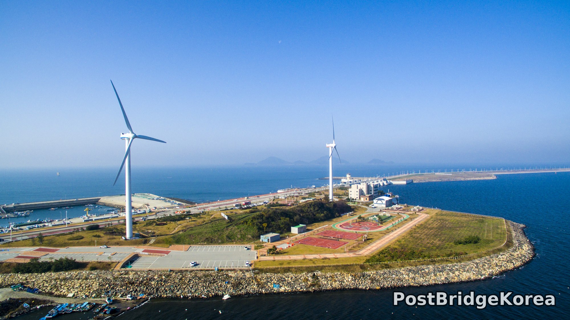
The first thing on screen when I got the drone up was the sheer geometric surprise of it — a narrow, rock-armored peninsula jutting into the Yellow Sea with two wind turbines standing on it like punctuation marks. From the ground you would never guess the shape. From above, the entire masterplan of Saemangeum’s coastal infrastructure reads in a single frame: the reclaimed land, the stone breakwaters, the harbor basin, the sports courts, and beyond them the long thin line of the Saemangeum Seawall stretching east across the horizon. That is the specific payoff of the aerial vantage point here. No ground-level shot gives you the scale.
The shoot date was November 20, 2016, deep into Korean autumn and nearly the cusp of winter. The vegetation on the inland hills had turned that dry, muted amber-and-rust you only get in the last two weeks before the trees go bare. The sky was cloudless and saturated blue, the kind of blue that only appears when the air is cold and dry. Shadow length across the peninsula surface tells me the sun was still reasonably high, somewhere in the mid-morning to early afternoon range, producing relatively flat, even side-light that kept detail in both the bright concrete areas and the darker hillside vegetation without the extreme contrast you would battle at golden hour. It is a counter-intuitive light condition that actually suits this site. The scale of Saemangeum is so vast that golden-hour haze tends to flatten the background seawall into the sky, and the cooler midday light on this particular day kept the distant horizon crisp instead.
The tidal variation visible across the four frames is dramatic. In the inland-bay shots, exposed mudflats separate the tree-covered islets, the water surface shifting from deep blue out at sea to a greenish, sediment-heavy tone in the shallower channels. This colour gradient is invisible from the shore. Only from altitude do you realize that Saemangeum’s water is not one colour but a series of distinct tidal zones stacked into the frame, and that stratification is the geological story of this coastline told in a single image.
Spatial Composition and Landmark Analysis: Foreground, Midground, and Background

Breaking down all four frames together gives a cleaner picture of the site than any single shot could. The four angles cover the wind-turbine peninsula, the island-chain bay, the open coastal headland, and the inland tidal channel, and together they map the whole site.
FOREGROUND
– Shot 1: Stone riprap breakwater curving around the tip of the peninsula; fishing boats moored in the small harbor basin to the left; a parking apron and a low red-roofed building at the peninsula’s landward edge.
– Shot 2: A densely pine-forested rock islet in the lower frame; exposed mudflat and shallow tidal channel separating it from the next island; floating pontoon dock with small boats moored alongside.
– Shot 3: Rocky headland cliff edge with low coastal scrub; the water close-in showing the colour shift from clear blue to silt-green where the depth decreases.
– Shot 4: Pine-covered hilltop in the foreground island; a narrow tidal channel running between the island and the mainland shore; exposed sand-and-mud beach fringe below the main hill’s base.
MIDGROUND
– Shot 1: Two large wind turbines, the closer one dominant on the left and the taller one slightly further back and right; a red athletic track, likely a multi-use sports ground, and adjacent buildings including what appears to be a white administrative or utility structure; vehicle access road connecting the peninsula facilities.
– Shot 2: A small flat-topped island with a white building, possibly a small pension or harbour office, on its shore; a concrete jetty with moored vessels; the road running along the mainland coastal edge with a cluster of commercial buildings visible at the right frame edge.
– Shot 3: Low-profile wooded islands in the middle sea distance; aquaculture buoy lines visible on the water surface; a small lighthouse or channel marker standing in the mid-water area.
– Shot 4: Mainland hillside rising steeply with a large steel transmission tower and power line corridor cut through the forest; a rocky beach strand at the hill’s base exposed at low tide.
BACKGROUND
– Shot 1: The Saemangeum Seawall stretching across the full width of the background horizon, the long low line of it unmistakable; a mountain silhouette rising behind the seawall; open Yellow Sea to the left.
– Shot 2: A large granite peak dominating the background, rocky summit and mixed deciduous-conifer cover in autumn colour; further mountains layered behind it in atmospheric haze; scattered smaller islands trailing off to the left.
– Shot 3: Open sea to the far left; island silhouettes in the mid-horizon haze; the coastal road and hillside continuing off-frame right.
– Shot 4: A prominent rocky summit with what appears to be a communications or observation structure at the peak; mountain ridgeline continuing right; a suspension bridge structure partially visible at the far right edge of the frame.
Recommended Drone Camera Settings and Composition Techniques for This Shooting Condition

For a coastal scene like this, flat midday light, no clouds, extremely high sky luminance against dark water and mid-tone land, the biggest technical risk is highlight clipping on the concrete surfaces and a blown-out sky. Pan-focus is the goal throughout. You want both the foreground breakwater rocks and the background seawall sharp simultaneously, which means keeping aperture in the f/5.6 to f/8 range as a starting point. Wider than that and you risk diffraction softening at the sensor edges; narrower and you start losing overall sharpness. The bright coastal light on a clear November day is generous, so ISO 100 is the sensible baseline. There is no reason to push sensitivity and introduce noise into what should be clean, detailed water surfaces.
Exposure compensation is where this scene requires real care. The blue sky in all four frames is nearly completely free of cloud, meaning the dynamic range demand is actually lower than it looks, but the white wind turbine towers and the pale concrete apron will clip easily if you expose for the water. A starting point of -0.3 to -0.7 EV negative compensation is worth testing to protect those highlights, then recover shadow detail in post rather than blowing the brights in camera. A CPL filter is strongly recommended for all water-surface shots here. The tidal colour gradients visible in shots 2, 3 and 4, that shift from deep blue to silt-green, are exactly what polarised light handles well, cutting surface glare and letting the actual water colour and depth read through. Without a CPL, shallow tidal water at this sun angle tends to wash to a flat silver and you lose the one thing that makes the scene interesting from above.
People usually talk about the turbine peninsula as the hero shot, and it is, but frame 2 is the one I keep coming back to. For composition, the wind-turbine peninsula shot is a natural one-point perspective setup: position the drone so the breakwater edge leads the eye from the lower frame corner toward the turbines at the visual centre, then let the seawall continue the line to the horizon. That single diagonal does more structural work than any elaborate framing. The island-chain shots, frames 2 and 4, suit a three-layer approach, forested islet, tidal channel, mainland hill, where each band of the image sits in its own tonal register: dark green, pale grey-green water, rust-brown hill. Keep the horizon on the upper third rather than centring it, which gives the water the most real estate and lets the mudflat texture carry the interest. Vanishing-point alignment toward the distant mountain in the background of frame 2 is worth attempting. The chain of islands creates a natural diminishing series that pulls the eye deep into the frame if the drone position is chosen carefully.
Outdoor Drone Flight Safety and Regulatory Checklist for This Terrain and Season
Late November at a coastal industrial and conservation site like Saemangeum is a specific combination of conditions that rewards careful pre-flight planning. The first thing to check, before the drone leaves the bag, is airspace status. Saemangeum sits adjacent to active harbour zones and the seawall infrastructure, and portions of this coastline have historically had airspace sensitivities. Check the official airspace and no-fly-zone lookup for the specific coordinates of your planned takeoff point, and get written confirmation from the relevant site manager before flying. Do not assume that because the area looks open and quiet it carries no restrictions.
Battery management in late-autumn coastal conditions deserves serious attention. At this time of year, ambient temperatures at the coast can drop faster than expected once the sun lowers, and lithium polymer cells lose effective capacity noticeably in the cold. The standard guidance is to keep batteries in an insulated bag until just before use, run a short hover to warm them before any demanding manoeuvres, and plan your return-to-home altitude conservatively. That means clearing the tallest structure in the frame, which here means accounting for the wind turbine towers visible in shot 1. Those structures are tall. RTH altitude should clear them with meaningful margin.
The terrain mix across these four frames, open water, tidal mudflat, rocky islets, and a working harbour, creates vision-sensor complications that matter on modern consumer drones. Water surfaces confuse downward-facing sensors because there is no stable texture to lock on to, and mudflats at low tide produce an unreliable intermediate signal. Rely on GPS hold rather than vision positioning when flying over water or exposed mudflat, and maintain enough altitude that a sudden sensor dropout does not immediately become a hull-strike problem. Wind at a coastal peninsula is not the same as wind inland: the air funnels and eddies around the breakwaters, and the turbines themselves are a clear indicator that the site sees sustained wind regularly. Check the forecast and set a conservative wind-limit threshold for launch. If gusts are variable near the turbine structures, that is not a day to push close to them.
Leave a Reply