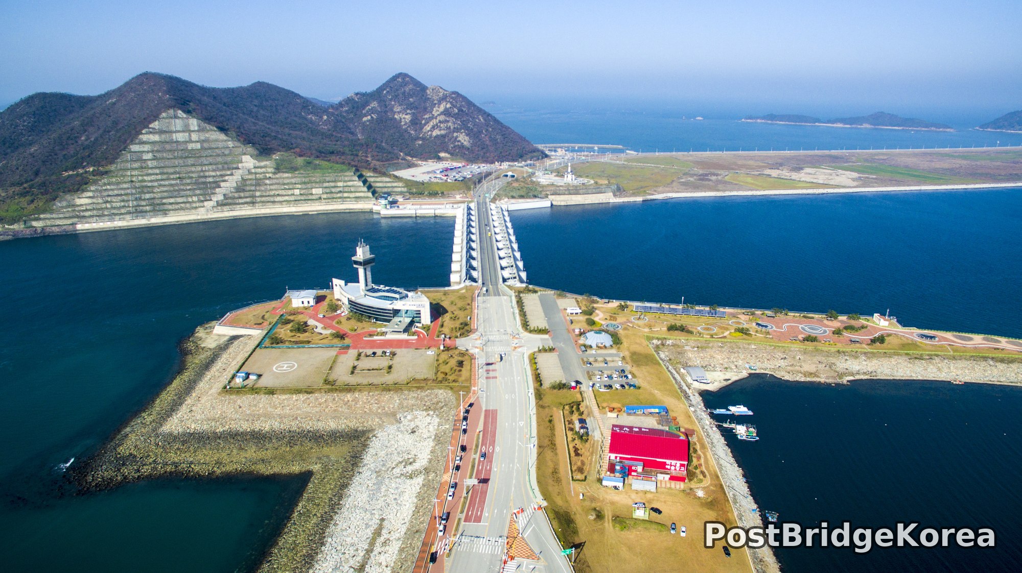

The Visual and Geological Value of Aerial Drone Photography at Saemangeum in Autumn

Late November light in North Jeolla Province sits low and cool. By mid-morning the sun angles in from the southeast at barely 25 to 30 degrees above the horizon, throwing long raking shadows across every concrete sluice gate and riprap embankment — the kind of side-light that makes flat infrastructure look almost sculptural. From ground level, Saemangeum is simply a road running beside water. From 150 metres up, it becomes something else entirely. A hard, man-made line drawn across 40 kilometres of shallow tidal flat, separating two completely different water colours: the opaque teal of the Yellow Sea on the seaward side and the calmer, darker blue of the freshwater reservoir forming behind the seawall.
The drone perspective is the only way to understand how the masterplan actually works spatially. The sluice gate complex, the lighthouse observation tower, the suspension bridge pylon, the reclaimed farmland stretching inland — none of these elements make sense in relation to each other until you get altitude. From directly overhead you can read the full geometry: the seawall is not simply straight but gently curves with the original coastline, and the artificial islands at the water control station interrupt that line with dense built infrastructure before it resumes its long, empty run toward the horizon. In autumn, when vegetation has pulled back to its minimum and soil tones are warm and exposed, the colour contrast between green-patched reclaimed land and the pale sandy embankment edge reads with extraordinary clarity.
The haze visible in all four frames is typical for the Yellow Sea coast in autumn and early winter. It softens the far background — the chain of granite hills and distant islands — while leaving the foreground concrete and water detail sharp. That atmospheric depth is a gift for composition. The scene has natural tonal separation built in, which makes it far easier to avoid a flat, compressed image, and the warm afternoon haze adds a depth that no amount of post-processing can convincingly fake.
Spatial Composition and Landmark Analysis: Foreground, Midground, and Background Across All Four Frames

Foreground elements (closest to camera):
– The water control sluice gate structure, spanning the seawall road with its row of ten-plus individual gate bays, photographed both from the seaward side and from above the road intersection
– The lighthouse and observation tower building on the western artificial island, including its helipad, red-brick plaza, and parking area
– The red-roofed commercial or service facility building on the eastern side of the road junction, adjacent to a small fishing harbour with moored vessels
– The riprap rubble-stone embankment lining the seaward face of the seawall, visible as a long diagonal texture running the full length of the third photo
– The dual-carriageway road surface with lane markings, centre dividers, and roadside lighting poles at regular intervals
Midground elements:
– The main body of the seawall itself, disappearing into haze along a perfectly straight one-point perspective line in the third photo
– Reclaimed land behind the seawall: flat fields divided into green and brown-ochre zones, showing active land reclamation at different stages of vegetation establishment
– The suspension bridge with its paired arch pylons, photographed from above in the second image, connecting the seawall road across a channel to an island settlement
– Small island with scattered buildings and what appears to be earthwork and construction activity, sitting just inside the suspension bridge span
– The freshwater reservoir surface, calm and very dark blue, contained between the seawall and the inland embankment visible in the fourth photo’s wide shot
Background elements:
– A layered chain of granite and volcanic hills, some with visible erosion-control retaining grid structures cut into their lower slopes, receding into haze
– Multiple smaller uninhabited rocky islets scattered across the seaward Yellow Sea surface, becoming progressively more indistinct with distance
– A long, low causeway or secondary embankment visible in the far background of the first photo, extending toward the horizon with what appears to be wind turbines along its crest
– Open Yellow Sea extending to the horizon, its surface colour transitioning from teal to pale grey-white at the atmospheric haze line
Recommended Drone Camera Settings and Composition Techniques for This Shooting Condition

For this kind of scene — long linear infrastructure shot across open water with significant sky coverage and strong midday-approaching side light — exposure compensation of around -0.3 to -0.7 EV is generally recommended. The water and concrete surfaces are both highly reflective, and without slight underexposure the dynamic range can clip highlights on the gate structure tops and the road surface simultaneously. A CPL filter is strongly recommended when shooting over water at oblique angles. The polarising effect cuts surface glare dramatically and allows the teal-blue water colour to render with full saturation rather than washing to near-white, and without it the distinction between the seaward sea surface and the calmer reservoir side loses most of its visual impact.
Aperture settings around f/5.6 to f/8 suit this type of wide-angle aerial work, where pan-focus across the full depth of the frame — from the concrete gate bays a few dozen metres below to the haze-softened mountains several kilometres away — is the goal. Drone sensors at 1-inch or larger format can achieve this depth of field at f/5.6 while keeping diffraction low. Keep ISO at base, typically ISO 100. Autumn midday light over open water is bright, and there is no reason to push sensitivity and introduce noise into what is essentially a large-print architecture shot. An ND8 filter may be useful if you want to slow the shutter and introduce slight motion blur into the water surface for a more graphic effect, though for sharp documentation of infrastructure detail a faster shutter is preferable.
Composition-wise, the single strongest technique for this location is one-point perspective alignment: position the drone directly over the seawall road centre line and point the camera slightly forward along the road axis, letting the converging lane markings, lighting poles, and embankment edges all accelerate toward a single vanishing point at the horizon. The third photo in this set executes exactly this approach, and it communicates scale more effectively than any of the others. A three-layer framing approach also works well from altitude — foreground water texture, a middle band of road and infrastructure, then sea-and-sky at the back — with the horizon line placed in the upper third rather than dead-centre so the frame doesn’t feel equally weighted and static. For the sluice gate complex specifically, a high-oblique gimbal angle of 60 to 70 degrees rather than straight-down nadir is recommended: it preserves enough lateral context, the lighthouse, the road junction, the harbour, to give the infrastructure meaning rather than reducing it to an abstract grid.
Outdoor Drone Flight Safety and Regulatory Checklist for Saemangeum’s Terrain and Season
The Yellow Sea coast in late autumn presents battery management as the single most pressing operational concern. Air temperatures in this area in November regularly sit between 5 and 12 degrees Celsius, and LiPo battery capacity can drop by 15 to 25 percent in those conditions. Keep batteries warm — in an inner jacket pocket or insulated case — right up until the moment of insertion, and plan flights to use no more than 70 to 75 percent of rated capacity rather than the usual 80 percent warm-weather threshold. Cold batteries also discharge faster under high-current loads like sustained headwind flight. This coastal location produces that condition frequently.
The terrain creates specific sensor challenges too. Vision-positioning sensors on most consumer drones struggle over open water and over the light-coloured concrete road surface, where there is insufficient visual texture for the downward camera to track. Set RTH altitude well above the lighting pole height along the seawall road before takeoff — a minimum of 80 to 100 metres is a conservative and reasonable starting point at this location — to avoid any collision risk on automated return. Perform compass calibration away from the concrete and steel gate structure, since the volume of rebar and metal hardware can introduce magnetic interference.
Before flying at Saemangeum, check whether the location falls within any airspace restriction or no-fly zone through an official airspace lookup tool, and contact the site management authority directly to obtain any on-site permission required. Large reclaimed land and water infrastructure projects often carry their own access and flight permission requirements separate from general aviation airspace rules, and showing up without prior confirmation from site managers is a practical risk regardless of what airspace maps show. The suspension bridge structure, observation tower, and active road all create proximity considerations that require conservative lateral buffers — do not fly directly over moving vehicle traffic without confirming it is permissible under applicable local rules. Register your drone with the relevant aviation authority if it meets the weight threshold requiring registration, and carry proof of registration and any permission documentation with you during the flight.
Leave a Reply