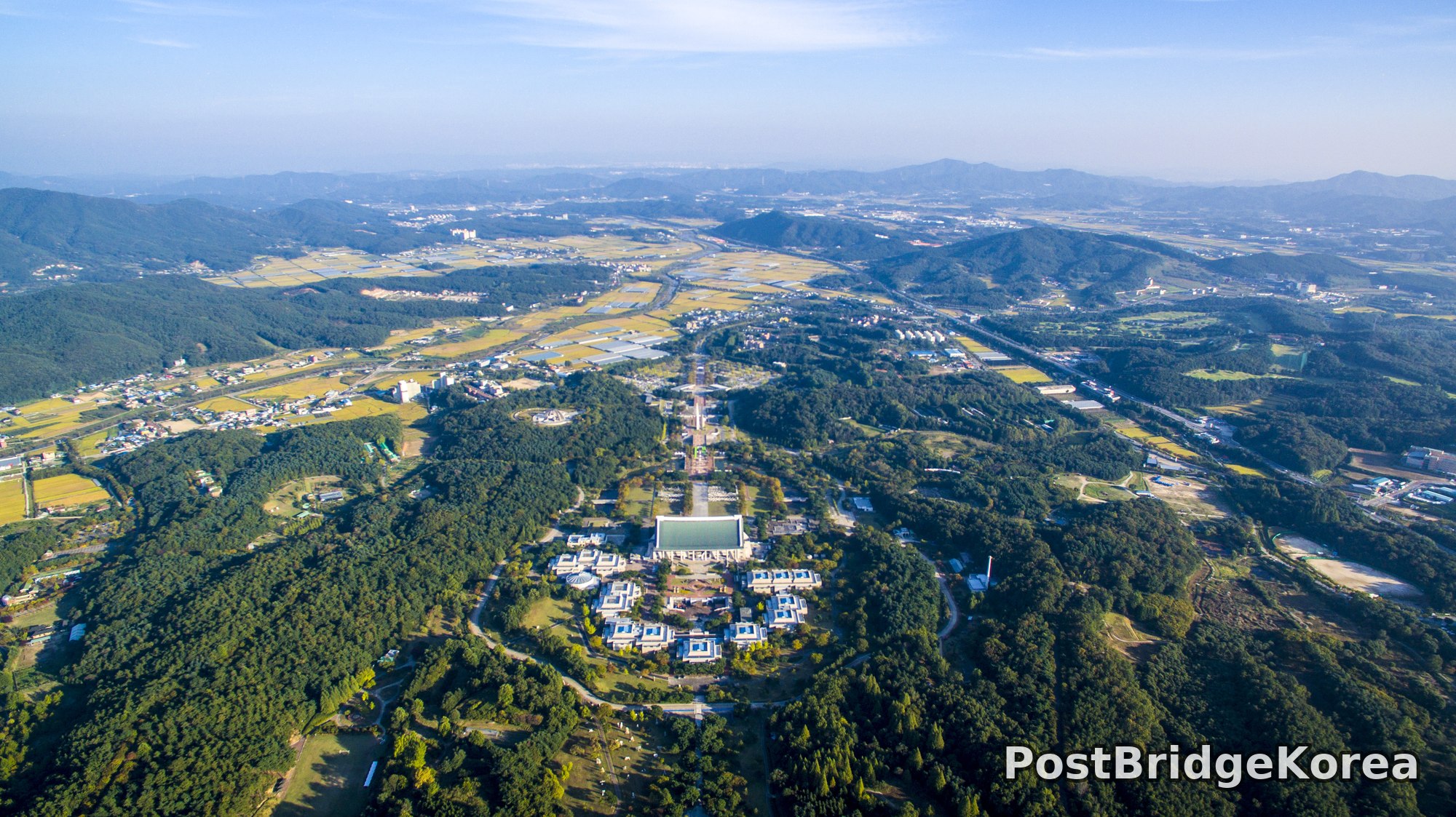

The Visual and Geological Value of Aerial Drone Photography in This Terrain and Season

Early autumn in the Cheonan basin does something particular to light. By mid-morning the haze has thinned enough to read topography across ten kilometers, yet the atmosphere still holds a soft blue-grey gradient at the horizon that compresses distance into clean tonal layers. The rice paddies ringing the site have gone gold — not the pale yellow of summer, not the cut brown of late harvest, but a warm, saturated amber that reads clearly even at high altitude. That specific window, early September in central South Korea, gives aerial photographers a natural color contrast between the dark evergreen forest covering the surrounding ridge system and the open agricultural basin that frames the institution.
What no ground-level photograph can communicate about Cheonan’s Independence Hall of Korea is its sheer scale relative to its containment. From the air, the full masterplan geometry becomes legible for the first time: a single cardinal axis driven north from the main exhibition hall through a long ceremonial promenade, terminating at a distant vanishing point that aligns with the valley floor between ridges. The surrounding hills form a natural amphitheater. The institution was not placed here incidentally. The forested basin physically cradles it, and that relationship is only readable from altitude.
The shoot took place in early September 2016, and both frames were captured under the same conditions. The sun angle suggests mid-morning side-lighting from the southeast, raking across the roof planes of the exhibition complex at a low enough angle to cast legible shadows without blowing out the white concrete surfaces. Side-light at this elevation also picks up texture in the canopy — individual tree crowns become three-dimensional rather than a flat green mass — which gives the forest foreground genuine depth. Dynamic range demands were significant: bright rice field gold, deep shadow inside the forested ridgelines, and a pale sky with thin cloud streaks all within a single frame.
Spatial Composition and Landmark Analysis: Foreground, Midground, Background
Both frames cover nearly identical ground from slightly different pitch angles, which means the composite landmark inventory is comprehensive. Here is the full spatial breakdown across both photographs:
Foreground:
– Dense mixed evergreen forest covering the southern and eastern ridgelines immediately surrounding the complex, forming the natural bowl that contains the site
– Winding internal access roads cutting through the forest canopy, visible as pale grey curves against dark green
– A small open lawn area at the southern edge of the complex, showing grass in a lighter early-autumn tone
– Several mature deciduous trees beginning to hint at color change among the dominant evergreen canopy
Midground:
– The main exhibition hall of Independence Hall of Korea — the large structure with the distinctive traditional Korean-style curved roof finished in a blue-green patina, clearly the dominant architectural mass of the complex
– A symmetrical cluster of smaller pavilion-style ancillary buildings flanking the main hall, each with matching blue-tiled rooftop details, arranged in a roughly bilateral pattern around the central hall
– The ceremonial grand promenade (중심 축로) extending northward from the main hall as a strong linear element — tree-lined, formally paved, with what appears to be a central water feature or reflective strip along its length
– A flagpole monument or memorial marker structure visible along the promenade axis
– Internal site roadways connecting the pavilion buildings, forming a loose radial pattern around the central hall
Background:
– Flat agricultural valley floor north of the ridge, dominated by harvest-gold rice paddies in geometric field divisions
– Rural residential clusters scattered across the valley, low-density with mixed-use structures
– What appears to be a light industrial or logistics zone in the mid-distance, with larger low-profile buildings and access roads
– A main arterial road or national highway corridor cutting diagonally across the valley, visible as a consistent grey line
– Additional forested ridgelines on the far north and northeast, fading into blue-grey atmospheric haze
– Mountain range silhouette at the far horizon, haze-compressed into flat tonal bands
Recommended Drone Camera Settings and Composition Tips for This Shooting Condition
For a scene with this dynamic range — bright harvest-field gold against deep forested shadow, with a washed-out high-sky zone — exposing to protect highlights is the right call. Start with an exposure compensation of -0.3 to -0.7 EV, biased toward preserving the pale sky and roof surfaces rather than lifting the shadows in post. ISO 100 is the sensible baseline; there is no motion blur risk at altitude and no reason to introduce noise. Aperture in the f/5.6 to f/8 range suits this kind of wide landscape shot. Pan-focus (팬포커스) is the goal, with everything from the foreground canopy to the horizon rendered sharp, and stopping down past f/11 risks diffraction softening on most drone camera sensors at this resolution.
A circular polarizing filter (CPL 필터) is worth mounting for this specific condition. The gold rice paddies carry some specular glare from the low side-angle sun, and a CPL can deepen the contrast between those fields and the dark forest without requiring aggressive tone-mapping in post. ND filters are less critical here. This is a mid-morning sharp-light scene, not a golden-hour long-exposure situation, and you want a fast enough shutter speed to freeze any canopy movement. Target 1/500s or faster.
The composition opportunity that defines this location from the air is one-point perspective (1점 투시). The ceremonial axis of the Independence Hall complex is a ready-made vanishing line running north through the frame. Positioning the drone directly south of the main hall and aligning the promenade with the vertical center of the frame creates a classical architectural aerial — immediately legible, geometrically clean. A three-layer framing approach works well here: place the forested foreground ridgeline in the lower third, the exhibition hall complex across the middle third, and the agricultural valley and horizon in the upper third. This stacks all three tonal zones — dark green, architectural mid-tone, and pale gold — into a visually coherent hierarchy. Shooting at a moderate downward pitch, around 30 to 45 degrees rather than straight nadir, preserves the sense of three-dimensional depth in the ridge topography while keeping the promenade axis readable.
Outdoor Drone Flight Safety and Regulatory Checklist for This Terrain and Season
Independence Hall of Korea sits within a topographically complex bowl surrounded by forested ridges. That matters for flight planning in two specific ways. First, the surrounding high ground can create localized wind shear — calm air at the launch point does not guarantee calm air fifty meters up above the treeline, where ridge-deflected gusts can develop. Check forecast wind data at multiple altitudes before any flight here, not just surface level. Second, the forested terrain limits visual line-of-sight recovery options if a return-to-home (RTH) scenario triggers unexpectedly. Set RTH altitude well above the highest surrounding ridgeline rather than using a default value, and confirm it before takeoff.
This site is a major national memorial institution. Not a public park. Flying here without explicit permission from site management is not appropriate regardless of airspace status. Contact the facility administration in advance and obtain written permission for the specific date, flight area, and intended use. Separately, check an official airspace and no-fly-zone reference tool for the Cheonan region before arriving — independently of the site permission — since airspace conditions can change and the two approvals are not interchangeable.
Early September is warm but transitioning, and battery performance should be stable. Morning flights can involve dew or light mist, so inspect all motor arms, gimbal contacts, and battery terminals for moisture before powering up. Keep a spare battery at operating temperature rather than stored cold in a bag. Early-autumn foliage is dense, and the vision-positioning sensors on most consumer drones can struggle over dark, low-contrast canopy — do not rely on visual positioning over the forested areas, and switch to GPS-only altitude hold. The ceremonial promenade and pavilion area will likely have visitors, especially on weekends, so position a spotter on the ground to monitor foot traffic below the flight path. It is a straightforward precaution that saves everyone a difficult situation.
Leave a Reply