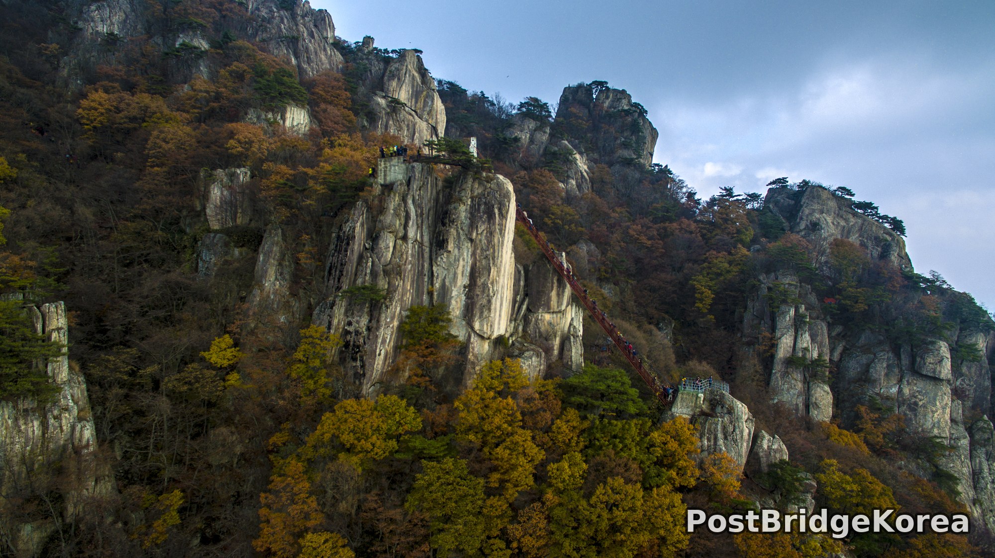

The Visual and Geological Value of Aerial Drone Photography in This Terrain and Season

Daedunsan’s defining geological character — vertical granite spires erupting from a heavily forested ridgeline — is simply not readable from ground level. You see rock walls. From the air, the whole masterplan of the mountain snaps into focus: a spine of fractured, columnar granite running roughly northwest to southeast, with subsidiary pillars dropping sharply into canopy-filled gullies on both flanks. That spatial logic took millions of years of erosion to produce. A single aerial frame communicates it in seconds.
The shoot date of November 4, 2016 places this right at the edge of peak autumn — late enough that many deciduous trees had already dropped to bare brown, early enough that oaks and some broadleaf species still held gold and deep amber. The overcast sky diffuses the light evenly across the cliff faces, eliminating the harsh black shadows that direct sun would have gouged into the vertical rock. Flat autumn light like this is actually ideal for granite: the pale, striated cliff surfaces pick up warm reflected colour from the surrounding foliage without blowing out to pure white. You lose drama. You gain detail and dynamic range.
The aerial vantage point also exposes something the trail never shows: the sheer drop between the summit viewing platform and the valley floor below it, the way the iconic red staircase clings to the rock face at an angle that looks nearly vertical from above, and the dense pocket of small structures and support buildings tucked into the narrow col between the main spire and the secondary ridge to the east. Ground photographers queuing on that staircase have no idea the col even exists. The drone shows you the whole geometry at once.
Spatial Composition and Landmark Analysis: Foreground, Midground, Background

The four photos together cover a wide arc of Daedunsan’s upper ridge zone. Breaking the scene into layers:
Foreground:
– The dominant granite spire cluster in the lower-centre of the aerial shot, its near-vertical western face catching diffused side light and showing clear columnar jointing in the rock
– The lower viewing platform/observation deck perched on a secondary rock outcrop, with steel safety railings visible and a small knot of hikers gathered at its edge
– Dense canopy of late-autumn broadleaf trees in gold, amber and bare brown filling the gullies between the spires — the trees are close enough in the aerial frame that individual branch structures are visible
Midground:
– The Daedunsan cable staircase (구름다리 계단 / the famous red-railed iron staircase) running diagonally up the rock face, clearly packed with visitors in colourful jackets forming a near-continuous line — this is the single strongest compositional element across all four images
– The summit platform at the top of the staircase, with a small stone or concrete structure (likely the summit marker pavilion) and a group of people crowded onto the flat rock
– A two-storey support/ticketing building in brown-red brick sitting in the col between the main spire and the eastern ridge, flanked by what appears to be a small yellow maintenance vehicle or equipment
– Pine trees (Korean red pine, Pinus densiflora) anchored in rock crevices along the upper ridgeline, their dark green crowns contrasting sharply against pale granite
Background:
– The secondary ridgeline running east, showing the same columnar granite formations continuing at a lower elevation, with fog or thin cloud partially dissolving the far peaks into blue-grey tones
– Broader mountain ridges receding into haze beyond the main Daedunsan formation, creating a natural three-layer depth — foreground rock, mid ridge, distant blue hills
– Overcast sky with broken cloud and a faint luminous patch suggesting diffused sun above the cloud layer, providing the soft even light visible across all rock surfaces
Recommended Drone Camera Settings and Composition Tips for This Shooting Condition

For granite cliff terrain under a flat overcast sky in late autumn, the core technical challenge is preserving detail simultaneously in the pale rock faces and the dark tree-filled gullies. The dynamic range spread here is substantial — the cliff tops approach near-white while the shadow gullies are close to black. An exposure compensation of around -0.3 to -0.7 EV is recommended as a starting point, biasing the exposure to protect highlights on the brightest rock surfaces while accepting that the deepest shadow areas will need recovery in post. Shooting in D-Log or the equivalent flat picture profile is strongly advisable to maximise retained dynamic range.
For aperture, f/5.6 to f/8 is recommended for this type of wide landscape aerial work — the goal being pan-focus across the full depth of the scene from the foreground spires to the distant ridge. ISO 100 is the natural choice under overcast conditions where shutter speed isn’t being pushed, though if wind is causing the drone to work hard to hold position, bumping to ISO 200 to allow a faster shutter is a reasonable trade-off. A CPL filter is worth considering even under cloud: the wet-looking rock surfaces and foliage still carry some polarised light, and a CPL can reduce the pale washed-out look on the cliff faces while deepening the amber foliage slightly. ND filters are less critical under flat light unless you specifically want motion blur in the foliage.
The red staircase is the strongest leading line this scene offers, and it should be used deliberately. Aligning the drone so the staircase runs diagonally from one corner of the frame toward the summit creates a natural one-point perspective pull into the image, with the distant ridgeline serving as the vanishing-point layer. A three-layer framing approach — foreground spire, mid-staircase, background ridge — is recommended over a flat top-down nadir shot here, because the vertical character of the rock is what makes Daedunsan distinctive, and a nadir loses that entirely. Shooting from a slightly oblique angle at medium altitude, with the horizon sitting in the upper quarter of the frame, tends to give the rock spires the sense of height they deserve while keeping enough sky for context. Watch the highlight clipping warnings on the lightest cliff faces — if the camera’s zebra or highlight alert is firing on the bare rock, pull the exposure down further rather than trying to recover it in post.
Outdoor Drone Flight Safety and Regulatory Checklist for This Terrain and Season
Daedunsan is an active national park with significant visitor traffic on its upper trails, particularly on autumn weekends. Before launching, confirm with the park management office whether drone operations are permitted in the flight zone you intend to use, and obtain any required site-level permission directly from the park authority. Check an official airspace and no-fly-zone reference for the area before you travel — not on the day, before you pack the car. Mountain parks in Korea frequently carry airspace restrictions that are not obvious until you check.
November temperatures at altitude drop sharply, especially in wind. Cold is the single biggest operational risk for drone batteries on a shoot like this. LiPo cells lose capacity fast below 10°C and can cause mid-flight voltage sag that triggers emergency RTH or, worse, sudden power loss. Keep spare batteries inside an insulated case against your body until the moment you need them, and plan your flight time conservatively — a battery that shows 30 minutes of flight time in summer might deliver 18 to 20 minutes on a cold November ridge. Set your RTH altitude high enough to clear the tallest spire in your vicinity with meaningful margin, because the terrain here is not flat; a standard default RTH altitude set at, say, 30 metres would collide with rock before the drone ever made it back.
The terrain creates specific vision-sensor problems. The columnar granite surfaces — pale, uniform, near-vertical — are exactly the kind of featureless pattern that optical obstacle avoidance sensors struggle with. Do not rely on the drone’s automated obstacle detection when flying close to cliff faces; fly on manual with full attention. Moisture is another factor: overcast conditions like those visible in these photos often come with damp air or light mist, and water ingress into motors or ESCs is a permanent failure risk. If visibility drops or mist thickens, land. Finally, this site has a high density of hikers on and around the staircase and viewing platforms — maintaining appropriate horizontal and vertical separation from people on open structures is not optional, it’s the baseline for responsible flying anywhere with visitor traffic.
Leave a Reply