
The Visual and Geological Value of Aerial Drone Photography at Daedunsan in Autumn

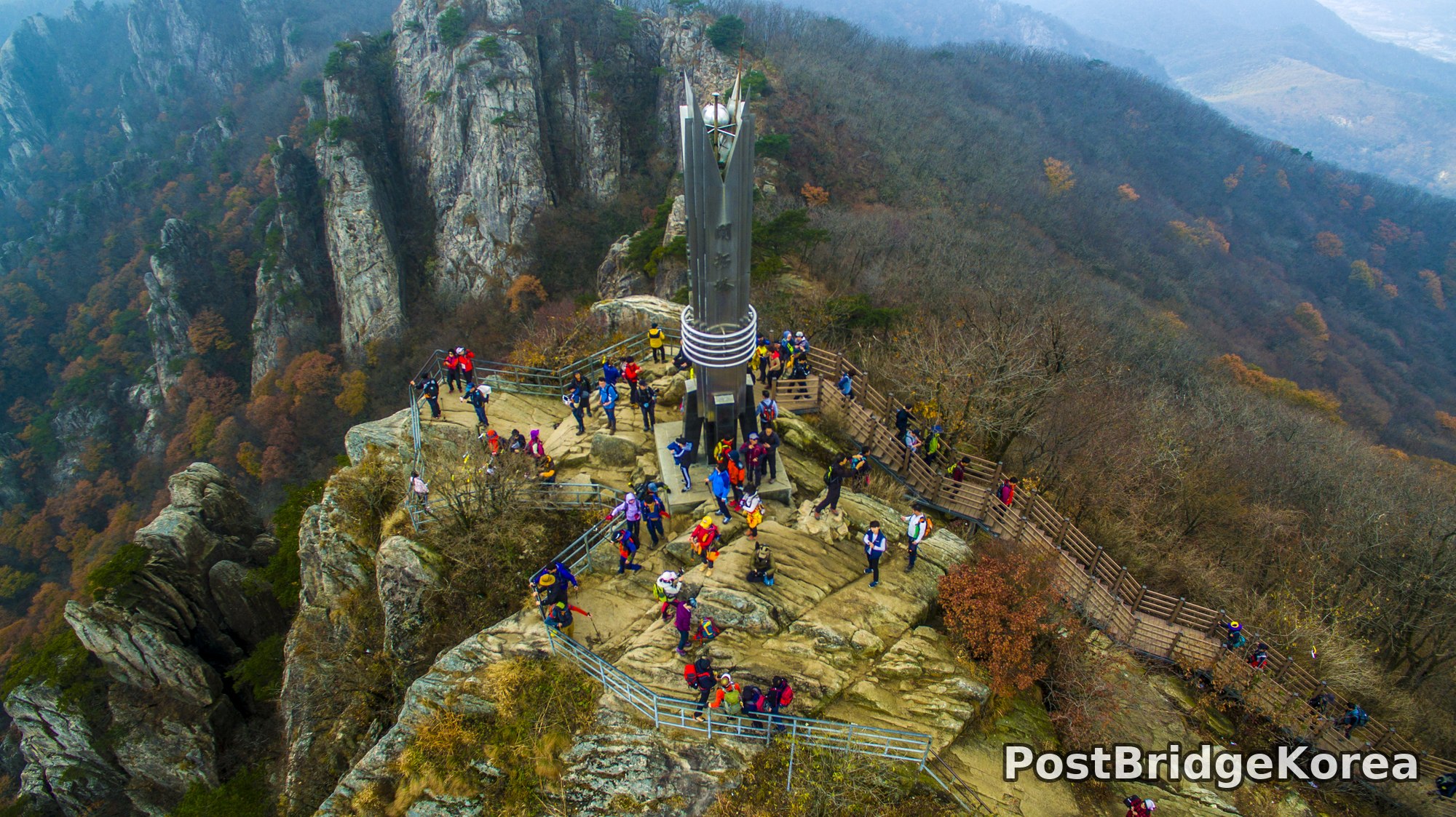
Daedunsan’s granite spine is not something you can truly read from the ground. Stand at the base and you see rock. Get the drone up 60-80 metres above the main summit ridge and suddenly the whole structure reveals itself: a fractured series of stone towers punching vertically out of a hillside that drops sharply in every direction, with autumn-thinned forest filling every gap between the crags. That contrast between pale grey quartzite and the warm amber-and-rust canopy below is what makes early November the single best window for aerial work here. The leaves are at maximum colour saturation but already sparse enough that the rock faces read clearly rather than being buried under green.
The overcast sky visible across these frames is, counterintuitively, an asset. Direct sun at this latitude in autumn hits the south-facing rock faces at a low angle and creates extreme contrast — shadows go pure black while the granite blows out to white. A thin cloud layer acts as a giant softbox, compressing the dynamic range to something a drone camera sensor can actually hold. The resulting images retain texture in both the pale rock and the dark forest floor, which is exactly what you need when the structural geometry of the terrain is the whole point.
From altitude, Daedunsan’s masterplan becomes legible in a way that no trail map communicates. The summit cluster is not one peak but a chain of separate granite columns connected by engineered infrastructure: steel staircases bolted directly to the rock face, a suspension bridge spanning the void between two pillars, and a cable car system sweeping up the southern flank. The aerial perspective makes those human-scale connections visible as compositional lines rather than just access routes, and that is the core photographic argument for flying here.
Spatial Composition and Landmark Analysis: Foreground, Midground and Background

Breaking these four frames down systematically, here is what occupies each spatial layer across the full set of shots:
FOREGROUND
– The main summit platform: a broad, exposed granite shelf edged with metal safety railings, crowded with hikers in colourful technical gear during peak autumn season
– The summit monument: a tall stainless-steel spire with circular ring elements, positioned at the centre of the top platform and serving as the strongest vertical anchor in the overhead shot
– The near cliff faces: raw, striated granite walls with lichen patches and isolated wind-bent pines clinging to ledges just below the platform edge
– The near end of the steel staircase system: a steep, ladder-like red-painted steel structure fixed to the face of a near-vertical granite column, with hikers visibly queuing on it in single file
MIDGROUND
– The suspension footbridge: a red-painted steel span connecting two separate granite pinnacles across open air, packed with visitors in the side-angle aerial frame — this is the most graphically striking single element across the set
– The lower wooden boardwalk system: slatted timber walkways and handrail structures connecting the summit area to the upper cable car station platform on the right flank
– Secondary rock pillars: multiple freestanding granite columns of varying height clustered around the main summit, some with small pine trees established in the joint cracks
– The upper cable car terminal structure: a small roofed building visible tucked against the ridge line, with the cable infrastructure running from it down the slope
– The mid-slope mixed forest: autumn canopy in a full four-colour range — green pine, yellow ginkgo-tone broadleaf, orange maple, deep red-brown oak — covering the slopes between rock outcrops
BACKGROUND
– The red cable car gondola in the solo cable car frame: a single enclosed red cabin mid-traverse against the autumn hillside, the only frame where the full slope gradient is visible without rock in the way
– The broad valley floor below: flat agricultural and settlement land visible through autumn haze beyond the mountain’s feet, providing depth and scale contrast to the craggy foreground geology
– Secondary ridge lines: lower parallel ridges receding into the distance, their colour progressively more muted by atmospheric haze — a natural gradient that adds dimensional depth to the wide frames
– Power line towers: visible in the cable car frame, running parallel to the gondola line down the slope
Recommended Drone Camera Settings and Composition Tips for This Shooting Condition

For this kind of overcast-bright, high-contrast granite-and-foliage scene, exposure compensation in the range of -0.3 to -0.7 EV is worth considering. The pale rock faces are highly reflective and will clip highlights faster than the histogram suggests, especially if the camera’s metering is weighted toward the darker forest areas. An aperture in the f/5.6 to f/8 range is generally recommended for this type of terrain shooting, where pan-focus across the entire scene from the near cliff edge to the valley far below is the goal. ISO should ideally stay at or near the sensor’s base value — ISO 100 or 200 depending on the platform — since the flat overcast light is bright enough that noise is not the limiting factor here; dynamic range retention is.
Pack a CPL filter for Daedunsan even in overcast conditions. It will not do much for sky glare on a clouded day, but it cuts surface reflections off the damp granite faces and deepens the saturation of the autumn foliage without pushing it into an artificial-looking HDR quality. Avoid heavy ND stacking in flat light — you risk underexposing the shadowed forest floor, which already sits two to three stops below the lit rock faces.
For composition, the suspension bridge and the steep red staircase are both natural one-point perspective subjects. The bridge works as a strong diagonal leading line when shot from a slightly elevated side angle rather than directly overhead, pulling the viewer’s eye from the near platform into the void and across to the far pinnacle. The overhead summit shot demonstrates classic three-layer framing: the monument spire at the top third, the crowded platform in the middle zone, and the receding ridge line dropping away below. For the cable car, a low-altitude banking position that places the gondola at the upper-third intersection while keeping the full colour gradient of the slope as background gives the most compositional payoff — aligning the cable line toward a vanishing point in the upper frame corner reinforces depth without needing to add altitude. Avoid hovering directly above groups of hikers on the summit platform; shoot from a 45-degree oblique angle to get both the monument and the crowd without the shadow of the drone falling into frame.
Outdoor Drone Flight Safety and Regulatory Checklist for This Terrain and Season
Daedunsan’s terrain presents a specific combination of hazards that are worth working through methodically before you even power on the aircraft. The summit ridge sits significantly higher than the surrounding valley, and while the aerial frames here were captured in calm conditions, ridge-top sites like this can accelerate wind speed unpredictably — particularly in November when cold fronts move through more frequently. Check wind at the projected flight altitude, not just at ground level, and build in a conservative ceiling for return-to-home altitude that clears the tallest granite columns on the site, not just the immediate launch point. For complex multi-pinnacle terrain like this, a recommended RTH altitude is at minimum 30-40 metres above the highest visible structure, not above takeoff elevation.
Battery performance drops noticeably in cold autumn and early-winter temperatures. At 5-10°C, which is realistic for Daedunsan in early November at elevation, usable capacity can fall by 15-25% compared to a warm-day baseline. Warm batteries in an inside pocket until just before flight, watch the cell voltage readout during flight rather than relying purely on percentage, and land at a higher remaining-charge threshold than you would in summer — 25-30% rather than 15%.
The mountain has significant visitor traffic on weekends, as these photos make obvious. Flying over dense crowds on a narrow summit platform is a serious safety consideration entirely apart from any regulatory question — a flyover at low altitude with no clear abort path in the event of a malfunction is a scenario worth avoiding by default. Plan shots from positions where the aircraft’s emergency descent path does not pass directly over the boardwalk or staircase queues. Vision-sensor reliability can also degrade near pale granite surfaces, which can present low-contrast returns that confuse obstacle-detection systems; consider disabling automated avoidance modes and flying manually with greater clearance margins than the sensor system would otherwise enforce.
Before flying at Daedunsan specifically, confirm the airspace classification and any no-fly or restricted-flight zones using an official airspace lookup, and check directly with the site management authority whether drone operations are permitted within the park area and under what conditions. Many popular mountain parks in South Korea require prior consent from the site operator independent of any airspace authorisation.
Leave a Reply