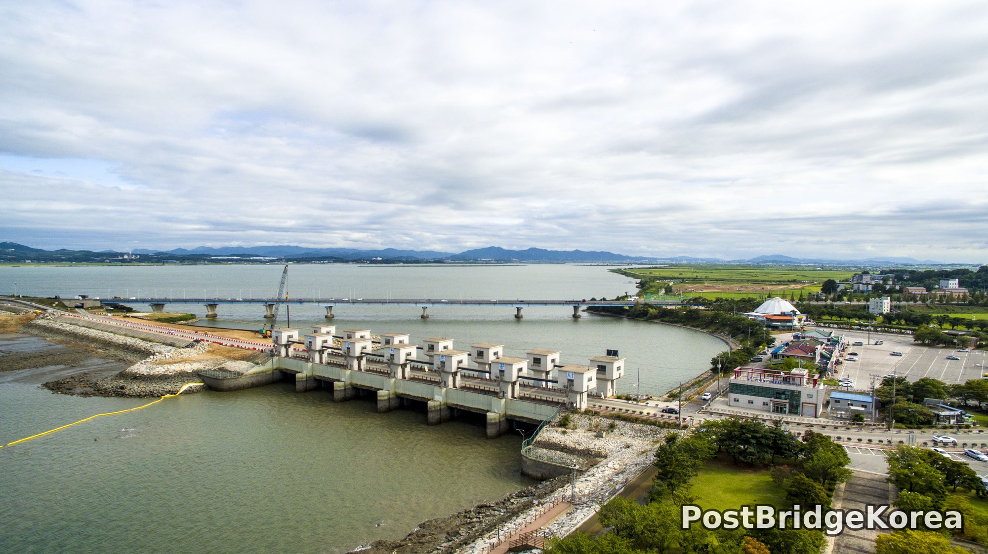

The Visual and Geological Value of Aerial Drone Photography at Sapgyocheon in Late Summer

Late August on Korea’s west coast is a particular kind of photographic challenge. The monsoon season is winding down but not entirely gone, and the sky above Sapgyocheon on this day carried that heavy, diffused cloud cover that flattens shadows and turns the tidal flats into something closer to a matte painting than a landscape. From the ground, this reads as dull. From altitude, it becomes enormously useful.
The aerial vantage point here reveals the full masterplan of the Sapgyocheon development in a single frame, something no ground-level position can do. The barrage structure, the reclaimed land carrying a compact tourist town, the broad tidal mudflats exposed at low tide, and the rice paddies pressing in from the east all become legible at once. The overcast light is doing real compositional work in these images: it eliminates harsh shadow on the sluice gate housings, preserves detail in both the dark mud of the flats and the pale concrete of the dam face, and allows the subtle color contrast between the grey-green reservoir water and the brown-ochre tidal zone to read clearly without clipping in either direction. Dynamic range demands are actually lower under cloud cover than under direct sun, which is a significant practical advantage when shooting a scene that spans reflective water, white concrete, and saturated green paddy fields simultaneously.
Summer also means the rice paddies are at their densest and most saturated. A green so loaded with chlorophyll it almost pulses against the neutral tones of the mudflat and the grey infrastructure. The drone captures the geometry of the barrage from directly above and from oblique angles, showing how the sluice gate row cuts a hard orthogonal line across an otherwise organic, curving shoreline. That contrast between engineered rigidity and natural curvature is the core compositional fact of this site, and you simply cannot see it from the ground.
Spatial Composition and Landmark Analysis: Foreground, Midground, and Background Across All Four Frames

These four shots were taken from different altitudes and headings, so the foreground-midground-background structure shifts between them. Here is what is actually visible across the full set.
FOREGROUND:
– The Sapgyocheon barrage sluice gate complex: a row of roughly ten reinforced-concrete gate housings with flat roofs, sitting directly on the dam face. In the first image this fills the lower-center frame.
– Riprap revetment (large angular stone armor) lining both banks at the base of the barrage structure.
– A yellow floating boom or containment line visible in the water immediately downstream of the barrage in the first shot.
– The coastal promenade and paved plaza of the waterfront park, including a circular mosaic-paved roundabout feature and sail-shaped sculptures, prominent in images two and three.
– A decommissioned grey naval vessel moored at a concrete quay on the left/west side of the waterfront complex, clearly visible in images two, three, and four.
– Small blue fishing boats in the tidal zone near the quay in image three.
– Exposed tidal mudflat in the foreground of image four, showing the characteristic fine-silt texture of a west-coast Korean estuary.
MIDGROUND:
– The main tourist and commercial district: a cluster of four-to-six-storey commercial buildings, restaurants, and retail in a compact grid layout.
– A large Ferris wheel and a drop-tower ride structure, both clearly identifiable in images two, three, and four, and the dominant vertical landmarks in the town area.
– A dome-shaped structure visible in image one near the right bank, and again in image two behind the town, that appears to be a large entertainment or exhibition facility.
– A road network running through the town, with visible parking areas and car traffic.
– The approach road and management building complex on the right/east bank of the barrage, with a small visitor facility building and organized car parking.
– Green lawn and tree planting inside the waterfront park, separating the plaza from the commercial zone.
BACKGROUND:
– The Sapgyocheon reservoir: a wide, calm, grey-green body of water stretching north toward the horizon.
– A long low bridge crossing the reservoir further upstream, with a construction crane visible at its left end in image one, indicating active infrastructure work at time of shooting.
– Flat agricultural land, predominantly rice paddies in late-summer green, extending broadly to the east and northeast behind the town.
– A low mountain ridge running along the far horizon, hazy under the overcast sky, providing depth and scale to the composition without demanding attention.
Recommended Drone Camera Settings and Composition Techniques for This Shooting Condition

Under dense, even overcast like the conditions visible in these frames, the priority shifts away from managing contrast and toward avoiding color cast and protecting highlight detail in the water surface. For this type of flat-light, mixed-surface scene, an exposure compensation of around -0.3 to -0.7 EV is generally recommended. The cloud acts as a giant softbox, but the reflective reservoir surface can still clip unexpectedly. Keeping ISO at or below 100 is advisable where shutter speed allows it, and an aperture in the f/5.6 to f/8 range tends to give full pan-focus across a scene with this much depth, from the foreground dam structure out to the distant mountain ridge, without introducing diffraction softness. An ND4 filter may help if you want a slightly longer exposure to smooth any ripple on the reservoir surface, though under overcast conditions a CPL filter is arguably more useful here. It cuts the grey glare off the water and allows the actual colour of the reservoir to come through, which is otherwise the weakest element in these shots.
On composition: the barrage provides a ready-made one-point perspective line if you position the drone directly in front of the sluice gate row and shoot along its axis. The gates recede toward the bridge and then the mountain, creating a strong vanishing-point alignment that pulls the eye through the entire depth of the scene. The diagonal formed by the dam embankment cutting from lower-left to upper-right is a reliable organizing line for the wide oblique shots. For the town complex, a three-layer framing approach works well: mudflat in the lower third, town and waterfront park in the middle third, reservoir and mountains in the upper third. The Ferris wheel conveniently marks the transition between the middle and upper zones and serves as a natural vertical anchor.
One technique worth working at this site is altitude sequencing. Shoot the same heading at 50m, 80m, and 120m in sequence. The relationship between the barrage geometry, the naval vessel, the plaza, and the agricultural hinterland reads completely differently at each height, and the overcast provides consistent enough light that the frames will cut together cleanly in post. During post-processing, apply a slight cool-to-neutral white balance correction, since the cloud cover pushes these scenes toward a greenish cast, and add a gentle structure or clarity boost on the concrete and riprap to recover the textural detail that flat light slightly suppresses.
Outdoor Drone Flight Safety and Regulatory Checklist for Sapgyocheon’s Terrain and Season
This site combines several terrain types that each carry their own operational risk, and late summer adds a few more. The barrage is active water-control infrastructure. The waterfront area is a public recreational space with a fairground. There is ongoing construction visible on the upstream bridge. Tidal mudflat surrounds much of the peninsula on which the town sits. Before flying here, check every one of these factors individually.
Regulatory first: use an official airspace lookup tool to confirm whether the area falls within a controlled, restricted, or no-fly zone before the day of the shoot, not on the morning of. Proximity to the barrage and any associated infrastructure may affect permissible altitude or require advance approval from the site operator or relevant authority. Get that confirmation in writing if possible. This type of mixed-use public space, part industrial infrastructure and part recreational park, often has site-specific rules that go beyond general airspace classification.
On the operational side: late summer in this region means residual humidity from the monsoon period. Moisture accelerates corrosion on exposed motor contacts and can affect vision-positioning sensors that rely on optical contrast. Over uniform mudflat or calm grey water, downward-facing sensors may lose positional lock. Fly with GPS as the primary positioning mode and set RTH altitude high enough to clear the Ferris wheel and the drop-tower, which are the tallest structures in the area and not always obvious at altitude when you are focused on the barrage end of the scene. A 100m RTH altitude floor is a reasonable general minimum for this type of mixed-height environment, though the actual number should be set based on your specific position relative to those structures.
The tidal mudflat is a landing hazard. Do not use it as a takeoff or landing surface. The silt is deep and will foul motors instantly. Launch from solid pavement only, and identify your abort landing spot before you take off, not mid-flight. In the event of a signal issue or battery alert over the water, the RTH function needs a clear path back to that pavement point, so keep the launch location in a position with unobstructed return geometry relative to the barrage and town structures.
Leave a Reply