
The Visual and Geological Value of Aerial Drone Photography at This Terrain and Season

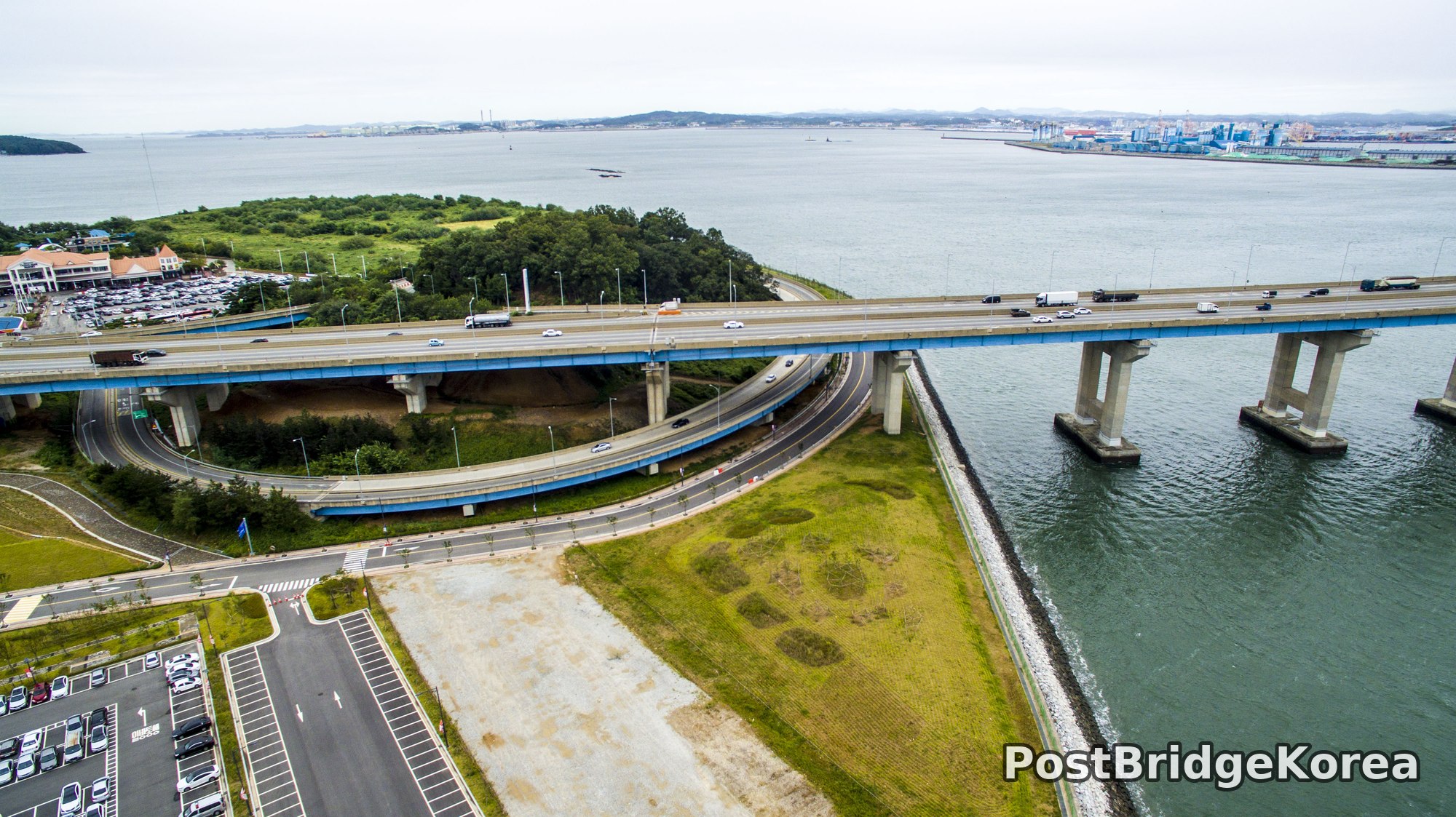
Haengdam Service Area sits on a small artificial island — or more precisely, a reclaimed peninsula — where the western coast of Korea meets a busy industrial waterway. From ground level, you get almost nothing. A parking lot, a rest-stop building, a ramp. But lift a drone thirty or forty meters and the entire masterplan of the site snaps into focus: a teardrop-shaped green hill ringed by a looping interchange ramp, connected on both sides by a long sea-crossing expressway that vanishes into the industrial horizon. The scale is genuinely surprising the first time you see it from above.
Summer in this part of Korea, late August specifically, brings heavy, diffuse overcast that most photographers treat as a problem. Out here over tidal water, it’s an asset. Direct sunlight on a wide bridge deck creates blown-out concrete whites and near-black shadow under every pier. Flat cloud cover acts like a studio softbox the size of the sky, dropping the scene’s dynamic range to something a drone camera sensor can actually hold without highlight clipping. The sea surface reads as a uniform grey-green, which pushes all the visual weight toward the structural geometry of the bridge and the interchange.
Summer vegetation is at its densest here too. The wooded hill at the center of the interchange is a solid dome of dark green canopy, and that density matters compositionally. It gives the swirling ramp road a contrasting organic core to wrap around. By late summer the reclaimed grassland areas between the ramp and the shoreline have greened up enough to separate visually from the concrete hardscape, adding a faint middle tone between the bridge grey and the sea grey. Three tonal zones. That’s all you need for a strong aerial read.
Spatial Composition and Landmark Analysis — Foreground, Midground, Background

The four shots from this session cover a full 360-degree survey of the site, so the foreground-midground-background breakdown shifts depending on the angle. Here’s how the layers stack across all four frames:
Foreground:
– The blue-painted girder bridge deck and its paired concrete piers rising from the tidal channel, photographed from low-oblique angles in shots one and three
– The surface car park with clearly marked white bay lines, visible in the lower-left of the first and third frames
– The circular interchange ramp tightly hugging the wooded central hill, dominant in shots one and two
– The rip-rap rock revetment along the island’s southern edge, visible in shot three
– A large commercial rest-stop building (signage reads MODA-style lettering) on the southwestern edge of the island, clearly visible in shot three
Midground:
– The wooded hill itself, a rounded, densely forested knoll that serves as the pivot point of the whole interchange geometry
– The multi-level flyover ramps stacked above each other, with the blue accent fascia on the elevated expressway deck
– Reclaimed flat grassland areas between the ramp infrastructure and the water’s edge
– The long concrete viaduct of the expressway extending northeast across the bay, its evenly spaced piers creating a strong rhythm in shots two and four
Background:
– The industrial port district on the far shore, with container cranes, stacked cargo, and large factory buildings visible in the upper-right of shots two and four
– A cable-stayed bridge pylon visible in the far distance in shots two and four, rising above the port
– A low line of coastal hills and mountains along the horizon, hazy under the overcast
– A long breakwater or seawall extending horizontally across the upper portion of shot two, separating inner harbor water from open bay
Recommended Drone Camera Settings and Composition Tips for This Shooting Condition

Flat overcast over tidal water is deceptively bright. The entire sky is one large reflective source and the sea below bounces it back. For this reason, setting exposure compensation to around -0.3 to -0.7 EV is recommended to protect concrete highlights on the bridge deck, which are the first thing to clip and the hardest to recover in post. An aperture in the f/5.6 to f/7.1 range is recommended for pan-focus shots like these, where you need the full depth of field from the foreground pier to the background port to remain sharp simultaneously. ISO should ideally stay at or near the sensor’s base value, 100 in most cases, since the soft overcast gives you plenty of light to work with and there’s no reason to introduce noise.
A circular polarizer (CPL filter) can help here, but needs careful handling. On an overcast day the polarizing effect on sky is minimal, but it will cut surface glare on the tidal water and add a few points of contrast to the sea surface, making the bridge piers read more clearly against the water. An ND4 may be worth stacking if you want a slightly longer shutter to introduce motion blur in the vehicle traffic crossing the bridge. Even a subtle blur in the cars and trucks reinforces the sense of scale and movement against the static concrete structure.
Composition-wise, the single most powerful technique available at this location is one-point perspective (1점 투시). The long viaduct running away from the camera in shots two and four creates a natural vanishing point toward the port skyline, and aligning the drone so that the bridge deck occupies the lower two-thirds of the frame, with sky as a thin strip at top, concentrates all the linear tension toward that single point. For the interchange shots, a rule-of-thirds placement of the central wooded hill works well: position the hilltop at the upper-right intersection point, let the circular ramp fill the lower half, and allow the sea to breathe into the left third. Shooting from a slightly lower altitude than you might instinctively choose is also worth trying. Getting the drone down to around rooftop height of the interchange ramps rather than high overhead keeps the three-layer foreground-midground-background structure intact instead of collapsing everything into a flat plan view.
Outdoor Drone Flight Safety and Regulatory Checklist for This Terrain and Season
This site combines several factors that each deserve individual attention before launch. Active expressway traffic runs directly below any flight path over the bridge and interchange. That alone means a flyaway or signal-loss event could have serious consequences, so setting a conservative RTH (return-to-home) altitude well above the tallest structure in the area is strongly recommended before takeoff, not after. Confirm that RTH altitude in the flight app, not just in your head.
The tidal channel and open bay water surrounding the island create two specific sensor hazards. First, vision-positioning systems on most consumer drones struggle over featureless water surfaces. The downward sensors may lose lock and cause unexpected altitude drift. Switching to GPS-only positioning mode over open water is recommended, and keeping manual altitude awareness high. Second, sea air carries salt moisture even in summer. After flying, wipe down exposed gimbal and motor areas and avoid leaving the aircraft in an open bag near the water.
Late August in Korea is the tail end of typhoon season. Even on a calm-looking overcast day, upper-level wind at altitude can be significantly stronger than surface wind, and conditions can change fast. Check wind at multiple altitudes before flying, not just at ground level. Treat any sudden increase in controller signal distance or aircraft drift as a reason to bring the drone back immediately rather than pushing further.
On the regulatory side: this area sits adjacent to an active port and an expressway, both of which may carry specific airspace restrictions or altitude limits. Always check an official airspace and no-fly-zone reference before flying. Do not rely on the absence of a warning in a consumer flight app as confirmation that the airspace is unrestricted. Contact the site manager at the service area directly to get permission to fly; an expressway rest stop with active traffic is not a location where showing up and launching without prior coordination is appropriate, regardless of what the airspace map says.
Leave a Reply