
The Visual and Geological Value of Aerial Drone Photography at Cheongpungho in Summer

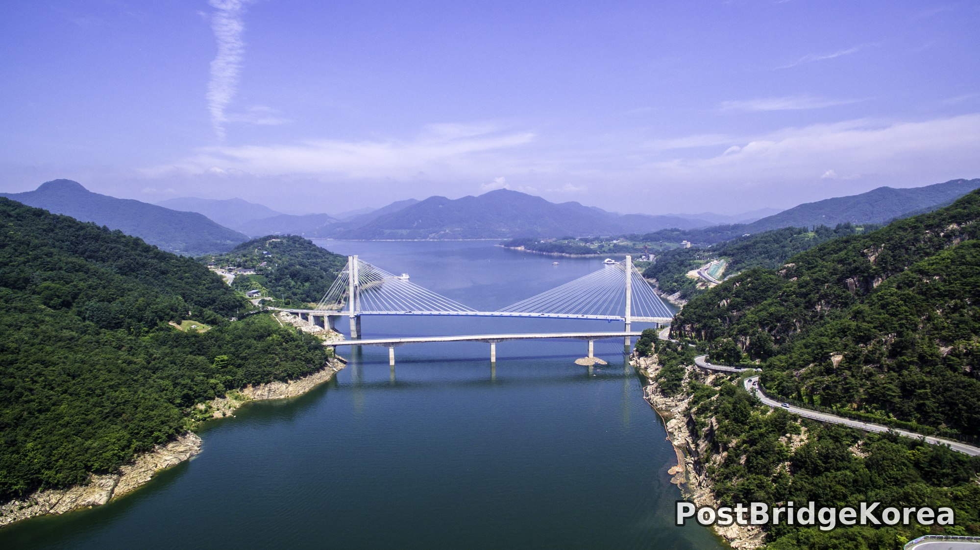
Shot on a July morning in 2016, these frames show Cheongpungho at its most geologically complex. The reservoir sits inside a basin carved by submerged river valleys, and that origin matters enormously from the air — because the water doesn’t run in a straight line. It bends, narrows, pools, and splits around forested ridgelines that push down to the waterline at steep angles. From ground level you see almost none of this. A drone changes everything.
Mid-summer lighting in the Chungcheong highlands arrives with real punch by mid-morning. The sun angle is high enough to eliminate most ground shadow from the valley walls, which means the water surface reads as a clean, deep blue-green expanse rather than a patchwork of light and dark. That consistent tonal base is what makes the cable-stay bridge structure pop so cleanly against the reservoir in the first shot — the white pylons and stay cables have near-zero competition from shadow clutter below. Cloud formations in the upper quarter of several frames add useful tonal contrast to an otherwise flat sky, giving editors something to work with in post.
The aerial vantage point at this reservoir specifically reveals how the surrounding Sobaek mountain chain forms a near-complete visual enclosure. From any road or shoreline path, you’re looking at one face of one ridge. From 80 to 120 meters up, the full amphitheatre geometry becomes readable: layered ridges receding into atmospheric haze, peninsulas of farmland reaching into the water, and the engineered structures (bridge, bungee tower, resort complex) anchored within that natural bowl. The scale relationship between the man-made and the geological only makes sense from above. That’s the core editorial argument for flying this spot.
Spatial Composition and Landmark Analysis: Foreground, Midground and Background Across All Four Shots

Breaking down what’s actually in these frames across the full four-shot set:
FOREGROUND
– The reservoir water surface itself, occupying the lower half of most frames, shifting in color from deep blue (narrow gorge section near the bridge) to a more diffuse blue-green in the wide-basin shots
– Rocky, exposed shoreline ledges beneath the cable-stay bridge, showing low summer water line
– A curved two-lane road clinging to the right-side valley wall in the bridge shot, with visible guard rails and sparse traffic
– A small floating dock and moored blue-roofed vessel at the adventure park peninsula
– A speedboat cutting a clean white wake line toward the floating platform in the fourth shot
MIDGROUND
– The cable-stay bridge itself: twin H-frame pylons with multi-strand fan cable arrays, a separate parallel concrete beam bridge running slightly lower on the same crossing — two distinct bridge structures sharing one crossing point
– The adventure/leisure complex built onto a rocky granite outcrop peninsula: a tall multi-colored bungee/drop tower structure (the dominant vertical landmark), a swimming pool, terraced viewing area, parking lot with a distinctive white sculptural building (likely a resort reception or museum), and a cable-car pylon visible at the right edge
– A floating restaurant or activity platform moored mid-lake in the fourth shot, adjacent to a white shell-shaped structure on the right shore, with a large resort hotel building visible on the far right hillside
– An agricultural peninsula of low-lying reclaimed land on the left of the wide-basin third shot, with field plots, small farm buildings, and a sandy beach margin where the land meets the water
BACKGROUND
– Successive ridgelines of the Sobaek range, forest-covered and progressively lighter in tone with atmospheric haze — four to five distinct depth layers visible in the clearest frames
– Granite rock outcrops breaking through the tree line on the highest peaks visible in the adventure park shot, indicating the quartzite geology common to this part of North Chungcheong Province
– Small scattered rural settlements tucked into hillside clearings, visible as clusters of low rooftops on the left valley wall in the bridge shot
– A construction or quarry area mid-slope behind the adventure complex, showing a pale exposed earth scar against the green hillside
Recommended Drone Camera Settings and Composition Techniques for This Shooting Condition

For a reservoir scene with this kind of high-contrast mid-summer lighting — bright white structural elements, deep-toned water, and a hazy sky — the single biggest technical challenge is dynamic range. The cable-stay bridge pylons and the bungee tower against the sky will clip to pure white very easily if you expose for the water. A starting point worth trying is dialing in -0.3 to -0.7 EV exposure compensation to protect those highlight areas, then recovering shadow detail in post rather than the other way around. Most modern drone sensors handle shadow recovery far more gracefully than they handle blown highlights.
For aperture, f/5.6 to f/8 is a sensible range to target for pan-focus shots like these, where you need both the near shoreline and the mountains five kilometers back to read sharply. Avoid the temptation to push wider. Diffraction at f/2.8 on a small-sensor drone camera does more damage to corner sharpness than the depth-of-field benefit justifies at this shooting distance. ISO should be kept at or near the sensor’s base (typically ISO 100) during mid-morning summer light; there’s simply no reason to go higher in these conditions. A circular polarising filter (CPL) is strongly recommended for water-over-rock shots like the gorge approach to the bridge — it will cut surface glare and reveal the submerged structure beneath the waterline, adding genuine depth to the image rather than just a flat reflective surface.
For composition, the cable-stay bridge is a natural one-point perspective anchor. Position the drone on the central axis of the bridge’s span, aligned between the two pylons, and the converging stay cables will create a strong vanishing-point pull into the reservoir beyond. That geometry rewards a centered, symmetrical crop. For the wider basin shots, three-layer framing works well: water in the lower third, the mid-ridge and any human-scale landmarks in the middle band, and sky plus atmospheric mountains occupying the top. The speedboat wake in the fourth shot is a ready-made diagonal line; shooting slightly ahead of the boat’s direction of travel and letting the wake form the leading line toward the floating platform is a technique worth planning for rather than leaving to chance. ND filters (ND8 or ND16) aren’t strictly necessary in these midday conditions unless you want to slow the shutter for motion blur on the boat wake — in which case ND16 at 1/60s would give a soft, streaked water effect that contrasts well against the static landscape.
Outdoor Drone Flight Safety and Regulatory Checklist for This Terrain and Season
Flying over a large reservoir surrounded by steep forested ridges in midsummer brings a specific set of hazards that a flat urban environment doesn’t. Heat thermals rising off sun-warmed rock faces and dark water can create unpredictable vertical air movement. Always check local wind forecasts at multiple altitudes before launch — surface conditions at the boat dock can be calm while 100 meters up the cross-valley flow is significantly stronger. Summer afternoon thunderstorms build fast in inland Korean mountain basins; plan to land by early afternoon if there’s any convective cloud development in the forecast.
Reservoir surfaces confuse vision-positioning sensors. The optical flow system on most prosumer drones uses contrast patterns below the aircraft to hold position — moving water, reflections, and low-contrast blue-green surfaces all degrade that sensor’s reliability. Switch to GPS-only mode, confirm GPS satellite lock is solid (12+ satellites recommended before takeoff), and do not trust obstacle-avoidance sensors to catch anything over open water. They won’t. Set your Return-to-Home (RTH) altitude before takeoff to clear the tallest obstruction in the flight area — in this case the bungee tower and the bridge pylons are significant vertical hazards, so an RTH altitude well above those structures is essential.
Before flying at Cheongpungho, check an official airspace and no-fly-zone lookup tool appropriate for the region to confirm this area’s current flight status, and contact the site management of any private facility (the resort, adventure park) before launching from or near their property. Permission from the facility manager is separate from any airspace clearance, and you need both. Battery performance at 30 degrees Celsius and above differs from manufacturer specs — batteries will report full charge but may sag faster under load in sustained hover. Carry spares, keep them in shade before flight, and treat any voltage warning more conservatively than you would in cool-weather conditions.
For water proximity specifically: set your minimum altitude to keep the drone well above any boat traffic lanes, and be aware that leisure craft on Cheongpungho can move quickly and unpredictably across lines you might assume are clear. The speedboat in the fourth shot covers open water fast. Always scan the full lake surface before descending to low-altitude creative shots, and have a clear abort maneuver planned before you need it.
Leave a Reply