
The Visual and Geological Value of Aerial Drone Photography in This Terrain and Season
Summer in Korea’s West Sea is punishing and magnificent in equal measure. By late June the sun climbs high before 9 a.m. and stays there, which flattens shadows on the water but does something genuinely useful for a causeway like this one: it kills the haze that clogs coastal mornings in spring, leaving you with water so deep and clear in tone that the difference between the open tidal flat on the left and the reclaimed freshwater reservoir on the right is immediately legible from altitude. That tonal split — sea blue against the more muted, almost grey-green of the contained reservoir — is the entire geological story of this reclamation project compressed into a single aerial frame. You cannot read it from the ground at all. Only the drone reveals it.
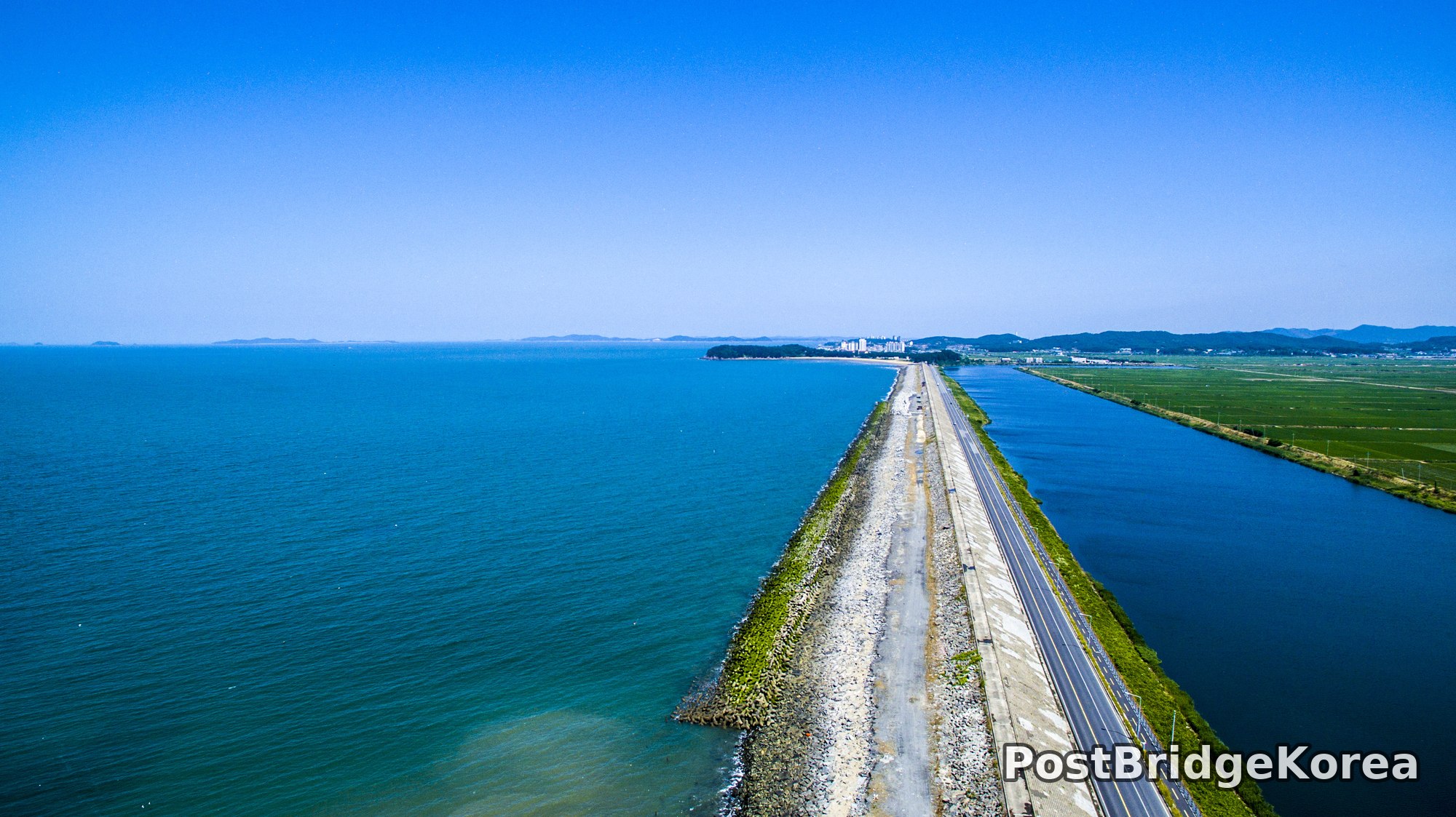
What the aerial vantage point does here is essentially cartographic. The causeway road running almost dead north functions as a spine, and the drone, positioned behind and above it at moderate altitude, turns that spine into a leading line of extraordinary strength. The reclaimed paddy fields to the right are already planted and brilliantly green by late June, which creates a three-zone colour structure across the horizontal axis of the image: deep blue ocean, bone-white riprap and concrete road, green agricultural land. No other season gives you that specific combination. In winter the fields are brown stubble. In spring the water carries bloom discolouration. Summer — this window of high sun and full crop growth — is arguably the only time the full masterplan of the reclamation becomes visually legible from above.
The terrain itself is essentially flat, which means there is almost no elevation drama except what you bring with the drone. Altitude matters enormously here. Too low and the road fills the frame and the water feels incidental. Too high and the road thins to a thread and loses its structural dominance. The sweet spot is somewhere that lets the riprap embankment texture remain visible in the foreground while still allowing the distant town skyline and offshore islands to register in the background. That is a narrower altitude window than it looks.
Spatial Composition and Landmark Analysis
– FOREGROUND: The riprap embankment fills the lower-right portion of the frame with rough granite tetrapods and pale concrete facing, sun-bleached and moss-stained in alternating patches. The two-lane road — with visible lane markings and a narrow service path to its seaward side — begins here and immediately starts converging toward the vanishing point. The concrete surface is slightly weathered, which gives it texture rather than a clean reflective surface, and that texture is critical to the sense of depth.
– FOREGROUND (water edge): Immediately to the left of the embankment, the tidal water is shallow enough that a slight turquoise-green shift is visible along the stone margin, darkening rapidly to a rich mid-blue as depth increases. No boats or vessels are present in this zone.
– MIDGROUND: The road continues straight and narrows convincingly toward the horizon, holding the one-point perspective together. To the right, an extensive flat reservoir or tidal retention basin sits lower than the road, its surface calm and reflecting the sky. Beyond the reservoir the first rows of rice paddies appear — vivid, evenly spaced green rows visible from this altitude, indicating the land reclamation is already in active agricultural use.
– MIDGROUND (left): Open West Sea water stretches broadly across the left half of the frame with no obstructions. A few white birds — barely resolved at this scale — skim the surface.
– BACKGROUND: A low coastal town is visible along the right edge where the causeway terminates or intersects with land. Several mid-rise apartment or residential towers stand above the treeline, distinctly white or cream against the green hills behind them. The hills themselves are rounded and heavily forested, consistent with the low granite ridges typical of Korea’s southwestern coast.
– BACKGROUND (left horizon): A chain of small offshore islands, silhouetted in soft blue-grey, sits on the left horizon. They appear uninhabited or lightly inhabited from this distance, scattered irregularly across the sea surface and reinforcing the sense of open tidal geography surrounding the reclaimed corridor.
– SKY: Completely clear, no cloud formation of any kind. The blue deepens slightly toward the upper frame, which is consistent with midday or late-morning summer shooting — high sun, low particulate scattering.
Recommended Drone Camera Settings and Composition Tips for This Shooting Condition
High-sun summer shooting over water is one of the trickier exposure situations a drone pilot faces. The ocean reflects a significant amount of direct sunlight back toward the lens, and the concrete road surface does the same. If you expose for the sky, the water mid-tones clip upward into white; if you chase the shadow detail in the embankment rock, the sky burns out completely. For this type of scene, an exposure compensation of around -0.3 to -0.7 EV is generally recommended as a starting bracket, pulling the highlights down enough to retain water surface detail without crushing the riprap into a silhouette. Keep a close eye on your histogram’s right edge — a scene this bright will push it hard.
A CPL filter is close to mandatory for this type of shot. Polarised light off the water surface at midday is significant, and a circular polariser will cut surface glare enough to reveal the actual water colour and slight depth variation visible in this frame. Rotate it carefully — over-polarising at this angle can turn the sky an unnaturally dark navy that reads as processed. The goal is natural enhancement, not drama. In terms of aperture, something in the f/4 to f/5.6 range is recommended for pan-focus shots on this kind of linear subject; stopping down too far on a small drone sensor introduces diffraction softness that the road texture will expose. ISO should stay at or near base for maximum dynamic range — the light in this situation is never your problem.
Composition-wise, the one-point perspective is the dominant technique and for good reason: this road genuinely converges. Aligning the vanishing point to the upper-centre or upper-right third of the frame rather than dead-centre gives the image more tension and allows the offshore islands to occupy the left third without competing. The rule of thirds applies well here if you place the road/water boundary roughly on the vertical two-thirds line from the left, letting the ocean dominate. A slight downward camera tilt — nose pitched below horizon rather than shooting perfectly level — is recommended to include more embankment texture in the foreground without sacrificing the background islands. Consider timing your shot for a moment when no vehicles are on the road, as a vehicle in mid-frame would break the geometry.
Outdoor Drone Flight Safety and Regulatory Checklist for This Terrain and Season
Coastal causeways in Korea’s reclamation zones sit in regulatory terrain that requires careful pre-flight research. Much of the West Sea coastline falls under controlled or restricted airspace at certain altitudes, and proximity to both agricultural land and the open sea means the airspace classification can change within a very short horizontal distance. Before flying anywhere near this type of location, it is essential to check the current airspace status through the official Drone ONE portal (드론 원스톱 민원서비스) and to confirm whether flight approval is required in advance. Assuming an area is unrestricted because it looks remote is a mistake that has cost pilots their equipment and their certification.
Summer heat creates its own safety issues that are easy to underestimate. LiPo batteries in a drone sitting on hot concrete or asphalt can begin the flight already warmer than optimal, which shortens effective flight time and can trigger protection shutdowns mid-flight over water. There is nowhere to auto-land here. Set your Return-to-Home altitude high enough to clear any nearby structures — the apartment blocks in the background are taller than they appear from this distance — and confirm RTH altitude before you arm the motors. A setting of at least 60-80 metres above the takeoff point is a reasonable starting baseline for this type of environment, but adjust for the actual obstacle profile you can see from your launch position.
Vision sensors are unreliable over water. Most consumer and prosumer drones will struggle to maintain accurate altitude hold when flying over the open ocean side of the causeway, because the water surface provides poor visual reference and can confuse optical flow systems. Switch to GPS-only stabilisation when flying over water, and keep ADAS obstacle avoidance systems in mind — on a clear-sky day with no obstacles, they are generally helpful, but over reflective water they can behave unpredictably. Keep the drone on the road corridor side when possible rather than positioning it directly over open sea.
Wind is the other summer variable. The West Sea coast is exposed, and sea-breeze cycles mean conditions at 8 a.m. can be calm while 11 a.m. brings a consistent 15-knot onshore wind. Check an hourly marine wind forecast, not just a general weather app, and always know the exact remaining battery percentage required for a safe return before you push out over the water. Always carry a printed or downloaded copy of any flight approvals with you on-site.
Leave a Reply