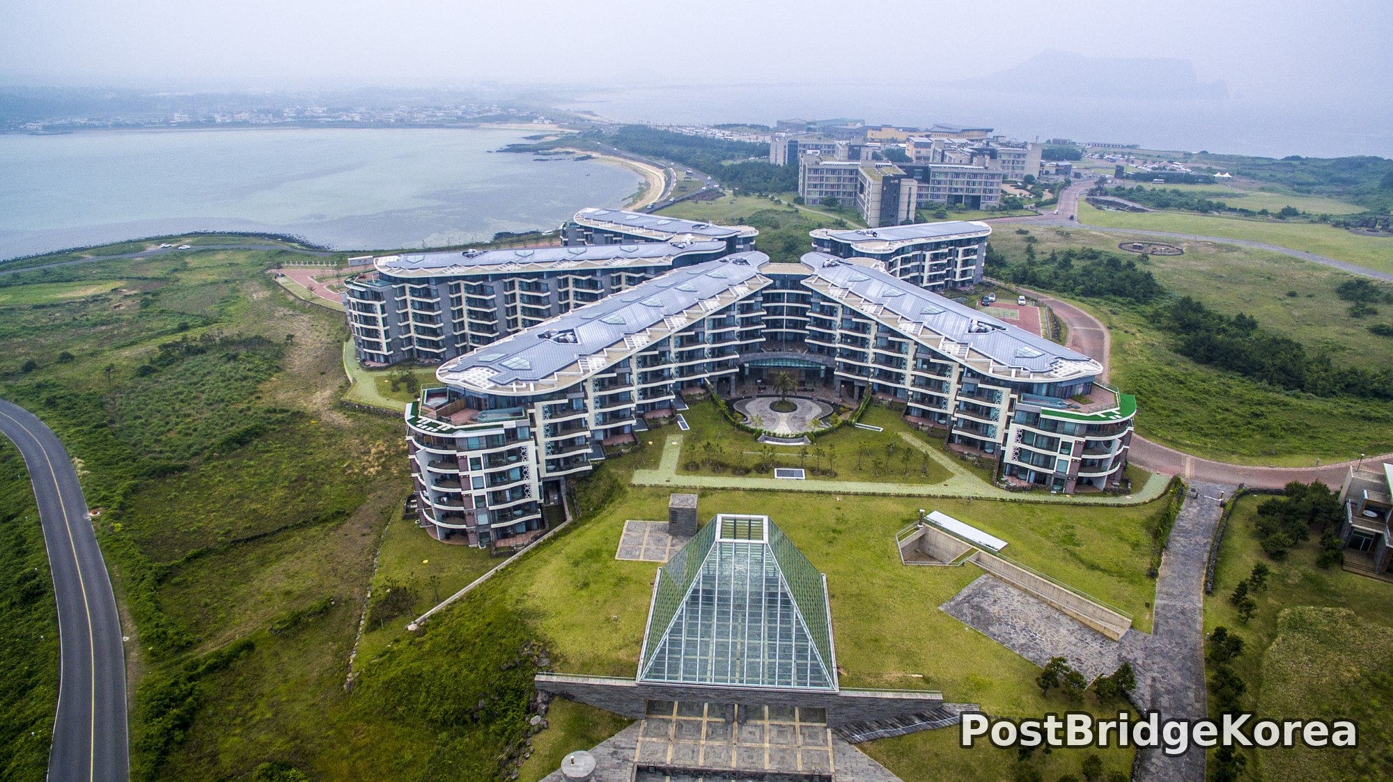

The Visual and Geological Value of Aerial Drone Photography in This Terrain and Season

Spring on Jeju Island is deceptive from the ground. The island looks green but contained — a coastal resort strip here, a forested hill there. From altitude, everything changes. The aerial vantage point pulls the resort complex’s radial, butterfly-wing masterplan into full view, and simultaneously reveals how aggressively the volcanic ridge system to the island’s interior pushes up through dense forest canopy, exposing raw trachyte and basalt spires that no hiking trail would position you to see at this angle. Two completely different geological and architectural personalities share one island. It takes altitude to see both clearly.
A late-May shoot in Jeju sits just past peak cherry blossom season but squarely inside the island’s lush green window. The forest in the mountain image is at full saturation, layered and dense and almost topographically textured, while the coastal resort grounds show manicured grass reading cleanly against the dark cladding of the buildings. The overcast sky on this particular day acts like a giant softbox: no hard shadows cutting across the resort’s curved roof lines, no blown highlights on the glass pyramid entrance structure. Flat light is underrated for architecture. It preserves detail in every facade simultaneously, something direct sun almost never lets you do, because the moment the sun moves, one surface gains and another loses.
Volcanic Jeju’s terrain is genuinely unusual from above. The ridge shot reveals a geological phenomenon specific to volcanic island formations: sharp, near-vertical rock fins erupting through otherwise continuous forest cover, creating a serrated silhouette that reads almost like a spine running up the slope. This kind of feature only becomes legible from a drone hovering at mid-mountain altitude, looking slightly downward across the ridge line. Ground-level hikers see individual rocks. The drone pilot sees the whole system, how the fins align, how the forest thins at the crest, how the valleys drop away on both sides.
Spatial Composition and Landmark Analysis
Photo 1 — Resort Complex (Coastal, Northwestern Jeju)
Foreground:
– Glass pyramid entrance structure with green copper-clad roof panels, likely a lobby atrium or indoor garden pavilion, positioned directly below the camera
– Two sunken courtyard access points flanking the pyramid, suggesting below-grade infrastructure or garden terracing
– Asphalt approach road curving in from the lower-left frame edge
Midground:
– The main resort building cluster arranged in a radial butterfly masterplan — four elongated wing blocks connected by a central circulation spine, each wing terminating in a rounded end cap with layered balcony tiers
– A circular plaza or rotunda feature at the junction of the wings, visible through a glass canopy
– Landscaped inner courtyards between wings with specimen trees and paved pathways forming geometric grid patterns
– A green-roofed lower wing section on the right side, likely a separate amenity or conference block
Background:
– A broad, sheltered bay with calm, gray-green water under the overcast sky
– A natural sandy beach arc at the head of the bay, connecting the resort grounds to the coastal edge
– Additional resort-scale hotel and residential buildings scattered across rolling green terrain to the right mid-distance
– A two-lane coastal access road threading between properties in the far right
– Low hills and developed land visible at the horizon, fading into coastal haze
Photo 2 — Volcanic Ridge Interior
Foreground:
– A near-vertical basalt or trachyte rock fin emerging from the ridge crest directly beneath the camera, moss-covered and sharp-edged, possibly 10-20 meters tall
– Dense mixed broadleaf canopy pressing right up to the base of the rock formation
Midground:
– A continuous forest-covered ridge running diagonally across the frame from lower-center to upper-right, with multiple secondary rock spires breaking the canopy surface at irregular intervals
– A narrow footpath or maintenance track partially visible along the upper ridge spine — barely distinguishable under tree cover
– Color differentiation in the canopy: older dark evergreen sections contrasting with lighter, fresher spring-growth broadleaf patches in bright yellow-green
Background:
– A higher secondary ridge system rising behind the primary ridge, creating a layered three-plane depth structure
– Misty atmosphere softening the far ridgeline into lighter tones, providing natural depth separation
– Overcast sky with diffused light producing minimal shadow contrast across the entire slope
Recommended Drone Camera Settings and Composition Tips for This Shooting Condition
Overcast spring days on Jeju produce a dynamic range that is actually quite manageable. The sky isn’t blowing out, and the shadowed areas aren’t crushing to black. That said, flat light compresses contrast, so your post-processing headroom becomes critical. For a scene like the resort complex, shooting in D-Log or your camera system’s flat color profile is strongly recommended to retain as much tonal separation as possible in the gray roof panels and the dark building facades at the same time. An exposure compensation of around +0.3 to +0.7 EV is generally advisable in these conditions to push shadow detail without clipping the pale overcast sky. Check your histogram on every pass.
For the resort overhead shot, a one-point perspective approach with the camera tilted to around 60-70 degrees nadir (not fully vertical) works well to preserve the sense of architectural depth in the wing facades while keeping the masterplan geometry legible. The glass pyramid in the foreground creates a natural leading element for rule-of-thirds framing. Placing it in the lower third while letting the curved building mass fill the upper two-thirds produces a composition that explains both the entrance sequence and the overall scale. An ND4 or ND8 filter is recommended at this altitude to keep shutter speed in a range that avoids propeller diffraction artifacts on rooftop details, typically targeting 1/500s to 1/1000s in overcast conditions. A CPL filter is less essential here given the absence of strong specular reflections, but it can marginally improve contrast in the bay water visible in the background.
The volcanic ridge photograph calls for a completely different approach. The diagonal compositional line of the rock fin running from bottom-center toward upper-right naturally generates a vanishing-point tension that pulls the viewer’s eye through the frame. To emphasize this, positioning the drone slightly off-axis to the ridge rather than directly above it, combined with a slight upward camera tilt, creates a genuine sense of the ridge’s vertical relief rather than flattening it. ISO should stay at the sensor’s native base value, commonly ISO 100 on most current drone cameras, since overcast spring light provides sufficient exposure without needing amplification; unnecessary ISO gain will mask the fine textural detail in lichen-covered rock surfaces. For pan-focus sharpness across the full depth of a scene like this, an aperture of f/4 to f/5.6 is typically recommended on fixed-lens drone systems, balancing diffraction softening against depth of field. Frame the composition so the misty background ridge occupies the upper third, the main forest-covered slope fills the middle, and the rock fin anchors the foreground. That clean three-layer structure reads immediately at any screen size.
Outdoor Drone Flight Safety and Regulatory Checklist for This Terrain and Season
Jeju Island requires specific regulatory attention before any drone flight. The island is managed under South Korea’s Aviation Safety Act (항공안전법), and certain coastal and mountainous areas fall within controlled or restricted airspace that requires prior approval through the DRONE ONE (드론 원스톱) system or direct coordination with the relevant authority. Resort areas in particular may also involve private property flight restrictions separate from airspace rules. Verify your planned flight zone against current airspace classifications before leaving the ground, not after you’ve arrived on site.
The coastal resort terrain in Photo 1 presents specific vision-sensor risks. The glass pyramid roof creates reflective and transparent surfaces that can confuse downward-facing obstacle avoidance sensors, particularly during descent. Manual positioning with visual line-of-sight confirmation is recommended when flying low over glass structures. The inner courtyard areas between the building wings create localized wind channeling effects; buildings this size redirect prevailing sea breezes in unpredictable ways at low altitudes, so hovering in the courtyard airspace warrants caution. Set your RTH (Return to Home) altitude high enough to clear the tallest wing block before any automated return sequence, and confirm that altitude is set correctly on the ground before takeoff.
The volcanic ridge terrain in Photo 2 presents a different set of concerns. GPS accuracy can degrade in steep-sided valleys and near rock faces due to multipath signal errors, meaning the drone’s position hold may become unreliable at low altitude close to the ridge. Flying near the rock spine requires maintaining extra horizontal clearance because downdrafts on the leeward side of ridges can be abrupt, especially with the variable overcast weather systems that move across Jeju in spring. Battery performance in late May on Jeju is generally less of a cold-weather concern than in winter months, but dense coastal humidity can affect battery connectors and gimbal mechanisms over time. Inspect contacts before each flight day.
For both locations, use a pre-flight checklist that includes compass calibration away from metal structures, confirmation that the return-to-home point is set accurately on takeoff, and a quick hover test at 10 meters before proceeding to operational altitude. Never assume a previous day’s airspace approval covers a new calendar day. Real-time NOTAMs (항공고시보) should be checked on the morning of the planned shoot.
Leave a Reply